Bétête
Bétête is a commune in the Creuse department in the Nouvelle-Aquitaine region in central France.
Bétête | |
|---|---|
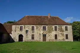 Abbey of Prébenoît | |
Location of Bétête 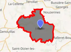
| |
 Bétête  Bétête | |
| Coordinates: 46°21′37″N 2°04′42″E | |
| Country | France |
| Region | Nouvelle-Aquitaine |
| Department | Creuse |
| Arrondissement | Aubusson |
| Canton | Boussac |
| Intercommunality | CC Creuse Confluence |
| Government | |
| • Mayor (2008–2014) | Olivier Contarin |
| Area 1 | 28.24 km2 (10.90 sq mi) |
| Population (2017-01-01)[1] | 365 |
| • Density | 13/km2 (33/sq mi) |
| Time zone | UTC+01:00 (CET) |
| • Summer (DST) | UTC+02:00 (CEST) |
| INSEE/Postal code | 23022 /23270 |
| Elevation | 272–430 m (892–1,411 ft) (avg. 380 m or 1,250 ft) |
| 1 French Land Register data, which excludes lakes, ponds, glaciers > 1 km2 (0.386 sq mi or 247 acres) and river estuaries. | |
Geography
A farming area comprising the village and several hamlets situated some 15 miles (24 km) northeast of Guéret, at the junction of the D15, D83 and the D88. The Petite Creuse river forms most of the southern and western border of the commune.
Population
| Year | Pop. | ±% |
|---|---|---|
| 1962 | 666 | — |
| 1968 | 668 | +0.3% |
| 1975 | 651 | −2.5% |
| 1982 | 638 | −2.0% |
| 1990 | 525 | −17.7% |
| 1999 | 427 | −18.7% |
| 2008 | 359 | −15.9% |
Sights
- The church, dating from the twelfth century.
- The ruins of the medieval castle of Bétête.
- Two châteaux, of le Moisse and of Ecosse, both dating from the seventeenth century.
- The twelfth century abbey of Prébenoît, undergoing restoration.
See also
References
- "Populations légales 2017". INSEE. Retrieved 6 January 2020.
| Wikimedia Commons has media related to Bétête. |
This article is issued from Wikipedia. The text is licensed under Creative Commons - Attribution - Sharealike. Additional terms may apply for the media files.
