La Chapelle-Baloue
La Chapelle-Baloue is a commune in the Creuse department in the Nouvelle-Aquitaine region in central France.
La Chapelle-Baloue | |
|---|---|
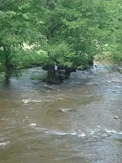 The Sédelle river, near to La Chapelle-Baloue | |
Location of La Chapelle-Baloue 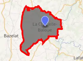
| |
 La Chapelle-Baloue  La Chapelle-Baloue | |
| Coordinates: 46°21′38″N 1°34′39″E | |
| Country | France |
| Region | Nouvelle-Aquitaine |
| Department | Creuse |
| Arrondissement | Guéret |
| Canton | Dun-le-Palestel |
| Intercommunality | CC Pays Dunois |
| Government | |
| • Mayor (2020–2026) | Béatrice GOMES |
| Area 1 | 8.68 km2 (3.35 sq mi) |
| Population (2017-01-01)[1] | 135 |
| • Density | 16/km2 (40/sq mi) |
| Time zone | UTC+01:00 (CET) |
| • Summer (DST) | UTC+02:00 (CEST) |
| INSEE/Postal code | 23050 /23160 |
| Elevation | 261–381 m (856–1,250 ft) |
| 1 French Land Register data, which excludes lakes, ponds, glaciers > 1 km2 (0.386 sq mi or 247 acres) and river estuaries. | |
Geography
A farming area comprising the village and a few small hamlets situated at the junction of the rivers Sédelle and Brézentine, some 19 miles (31 km) northwest of Guéret at the junction of the D69 and the D72 roads. The commune lies on the pilgrimage route known as St James's Way.
Population
| Year | Pop. | ±% |
|---|---|---|
| 1962 | 236 | — |
| 1968 | 264 | +11.9% |
| 1975 | 228 | −13.6% |
| 1982 | 197 | −13.6% |
| 1990 | 151 | −23.4% |
| 1999 | 143 | −5.3% |
| 2008 | 133 | −7.0% |
Sights
- The church of Notre-Dame-de-Lorette, dating from the twelfth century.
- The chateau and some ancient fortifications.
- A fourteenth-century stone cross.
See also
References
- "Populations légales 2017". INSEE. Retrieved 6 January 2020.
| Wikimedia Commons has media related to La Chapelle-Baloue. |
| Authority control |
|
|---|
This article is issued from Wikipedia. The text is licensed under Creative Commons - Attribution - Sharealike. Additional terms may apply for the media files.