Flayat
Flayat is a commune in the Creuse department in the Nouvelle-Aquitaine region in central France.
Flayat | |
|---|---|
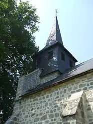 The parish church of Saint-Martin, in Flayat | |
Location of Flayat 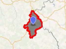
| |
 Flayat  Flayat | |
| Coordinates: 45°46′39″N 2°22′59″E | |
| Country | France |
| Region | Nouvelle-Aquitaine |
| Department | Creuse |
| Arrondissement | Aubusson |
| Canton | Auzances |
| Intercommunality | CC Marche et Combraille en Aquitaine |
| Government | |
| • Mayor (2008–2014) | Alain Fouriaux |
| Area 1 | 43.53 km2 (16.81 sq mi) |
| Population (2017-01-01)[1] | 309 |
| • Density | 7.1/km2 (18/sq mi) |
| Time zone | UTC+01:00 (CET) |
| • Summer (DST) | UTC+02:00 (CEST) |
| INSEE/Postal code | 23081 /23260 |
| Elevation | 735–827 m (2,411–2,713 ft) |
| 1 French Land Register data, which excludes lakes, ponds, glaciers > 1 km2 (0.386 sq mi or 247 acres) and river estuaries. | |
Geography
An area of lakes and streams, forestry and farming, comprising the village and several hamlets situated in the upper valley of the river Méouzette some 17 miles (27 km) southeast of Aubusson, at the junction of the D21, D30 and the D996 roads. The commune has an eastern border with the department of Allier and is within the national park of the Millevaches (not 1000 cows, but lakes).
The Chavanon (locally called la Ramade) forms most of the commune's eastern border.
Population
| Year | Pop. | ±% |
|---|---|---|
| 1962 | 622 | — |
| 1968 | 533 | −14.3% |
| 1975 | 489 | −8.3% |
| 1982 | 447 | −8.6% |
| 1990 | 364 | −18.6% |
| 1999 | 380 | +4.4% |
| 2008 | 339 | −10.8% |
Sights
- The sixteenth-century church of St. Martin.
- The chapel of Salesses, dating from the thirteenth century.
- The chapel of St. Clair, from the eighteenth century.
- A chateau.
See also
References
- "Populations légales 2017". INSEE. Retrieved 6 January 2020.
| Wikimedia Commons has media related to Flayat. |
| Authority control |
|
|---|
This article is issued from Wikipedia. The text is licensed under Creative Commons - Attribution - Sharealike. Additional terms may apply for the media files.
