Puy-Malsignat
Puy-Malsignat is a commune in the Creuse department in the Nouvelle-Aquitaine region in central France.
Puy-Malsignat | |
|---|---|
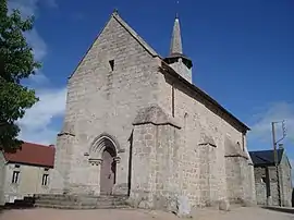 The church of Saint-Thomas de Cantorbéry, in Puy-Malsignat | |
Location of Puy-Malsignat 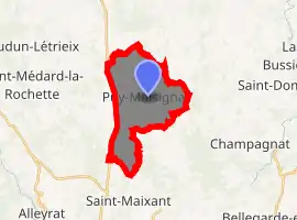
| |
 Puy-Malsignat  Puy-Malsignat | |
| Coordinates: 46°02′20″N 2°13′09″E | |
| Country | France |
| Region | Nouvelle-Aquitaine |
| Department | Creuse |
| Arrondissement | Aubusson |
| Canton | Gouzon |
| Intercommunality | CC Marche et Combraille en Aquitaine |
| Government | |
| • Mayor (2008–2014) | Henri Alhéritière |
| Area 1 | 12.61 km2 (4.87 sq mi) |
| Population (2017-01-01)[1] | 159 |
| • Density | 13/km2 (33/sq mi) |
| Time zone | UTC+01:00 (CET) |
| • Summer (DST) | UTC+02:00 (CEST) |
| INSEE/Postal code | 23159 /23130 |
| Elevation | 496–616 m (1,627–2,021 ft) (avg. 615 m or 2,018 ft) |
| 1 French Land Register data, which excludes lakes, ponds, glaciers > 1 km2 (0.386 sq mi or 247 acres) and river estuaries. | |
Geography
An area of farming, lakes and streams comprising the village and a few hamlets some 7 miles (11 km) north of Aubusson, between the D9 and the D990 roads.
The Voueize forms part of the commune's eastern border.
Population
| Year | Pop. | ±% |
|---|---|---|
| 1962 | 232 | — |
| 1968 | 244 | +5.2% |
| 1975 | 215 | −11.9% |
| 1982 | 213 | −0.9% |
| 1990 | 194 | −8.9% |
| 1999 | 194 | +0.0% |
| 2008 | 165 | −14.9% |
Sights
- The church, dating from the thirteenth century.
- The ruins of an eleventh-century castle.
- The château de Margeleix, dating from the seventeenth century.
- The chapel at Vallensanges
See also
References
- "Populations légales 2017". INSEE. Retrieved 6 January 2020.
| Wikimedia Commons has media related to Puy-Malsignat. |
| Authority control |
|---|
This article is issued from Wikipedia. The text is licensed under Creative Commons - Attribution - Sharealike. Additional terms may apply for the media files.
