Jarnages
Jarnages is a commune in the Creuse department in the Nouvelle-Aquitaine region in France.
Jarnages | |
|---|---|
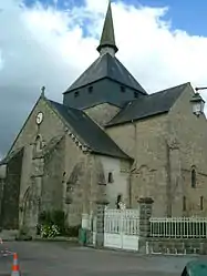 The church in Jarnages | |
 Coat of arms | |
Location of Jarnages 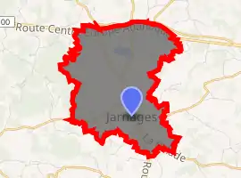
| |
 Jarnages  Jarnages | |
| Coordinates: 46°10′56″N 2°05′08″E | |
| Country | France |
| Region | Nouvelle-Aquitaine |
| Department | Creuse |
| Arrondissement | Aubusson |
| Canton | Gouzon |
| Intercommunality | CC Creuse Confluence |
| Government | |
| • Mayor (2008–2014) | Vincent Turpinat |
| Area 1 | 9.17 km2 (3.54 sq mi) |
| Population (2017-01-01)[1] | 452 |
| • Density | 49/km2 (130/sq mi) |
| Time zone | UTC+01:00 (CET) |
| • Summer (DST) | UTC+02:00 (CEST) |
| INSEE/Postal code | 23100 /23140 |
| Elevation | 412–545 m (1,352–1,788 ft) (avg. 460 m or 1,510 ft) |
| 1 French Land Register data, which excludes lakes, ponds, glaciers > 1 km2 (0.386 sq mi or 247 acres) and river estuaries. | |
Geography
A farming village situated some 10 miles (16 km) east of Guéret, at the junction of the D65, D13 and the D990. The N145 road forms the northern border of the commune.
History
The origins of Jarnages go back a long way. During the Gallo-Roman period it was known as Agarrusacum. In the Middle Ages, its royal châtelain was Bertrand d'Armagnac, Count de la Marche, who had it fortified in 1434. In the 16th century, Jarnages had a certain importance as a Protestant stronghold, but the Governor of the Marane retook it in 1691.
Population
| Year | Pop. | ±% |
|---|---|---|
| 1962 | 505 | — |
| 1968 | 512 | +1.4% |
| 1975 | 473 | −7.6% |
| 1982 | 470 | −0.6% |
| 1990 | 449 | −4.5% |
| 1999 | 408 | −9.1% |
| 2008 | 520 | +27.5% |
Sights
- The church of St. Pierre, dating from the twelfth century.
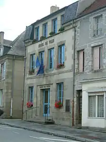
Town hall
See also
References
- "Populations légales 2017". INSEE. Retrieved 6 January 2020.
| Wikimedia Commons has media related to Jarnages. |
| Authority control |
|
|---|
This article is issued from Wikipedia. The text is licensed under Creative Commons - Attribution - Sharealike. Additional terms may apply for the media files.