Moutier-Rozeille
Moutier-Rozeille is a commune in the Creuse department in the Nouvelle-Aquitaine region in central France.
Moutier-Rozeille | |
|---|---|
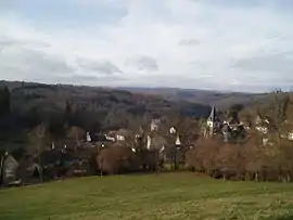 A general view of Moutier-Rozeille | |
.svg.png.webp) Coat of arms | |
Location of Moutier-Rozeille 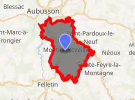
| |
 Moutier-Rozeille  Moutier-Rozeille | |
| Coordinates: 45°55′03″N 2°11′52″E | |
| Country | France |
| Region | Nouvelle-Aquitaine |
| Department | Creuse |
| Arrondissement | Aubusson |
| Canton | Felletin |
| Intercommunality | CC Creuse Grand Sud |
| Government | |
| • Mayor (2008–2014) | Jean Paul Burjade |
| Area 1 | 19.66 km2 (7.59 sq mi) |
| Population (2017-01-01)[1] | 427 |
| • Density | 22/km2 (56/sq mi) |
| Time zone | UTC+01:00 (CET) |
| • Summer (DST) | UTC+02:00 (CEST) |
| INSEE/Postal code | 23140 /23200 |
| Elevation | 437–671 m (1,434–2,201 ft) (avg. 538 m or 1,765 ft) |
| 1 French Land Register data, which excludes lakes, ponds, glaciers > 1 km2 (0.386 sq mi or 247 acres) and river estuaries. | |
Geography
An area of farming and forestry comprising a village and several hamlets situated near where the Creuse joins the Rozeille river, just 3 miles (4.8 km) south of Aubusson, at the junction of the D19, D982 and the D21 roads.
Population
| Year | Pop. | ±% |
|---|---|---|
| 1962 | 427 | — |
| 1968 | 507 | +18.7% |
| 1975 | 403 | −20.5% |
| 1982 | 475 | +17.9% |
| 1990 | 446 | −6.1% |
| 1999 | 435 | −2.5% |
| 2008 | 436 | +0.2% |
Sights
- The church, dating from the eleventh century.
- The ruins of a feudal castle at Confolent.
- The ruins of the St Hilaire church. Originally built in the mid-7th century around a Gallo-Roman mausoleum, the church has been continuously occupied until the end of the 19th century. With many graves and architectural features, the site is regularly studied by archaeologists since 2007.[2]
See also
References
- "Populations légales 2017". INSEE. Retrieved 6 January 2020.
- "Archived copy". Archived from the original on 2016-08-20. Retrieved 2016-07-04.CS1 maint: archived copy as title (link)
| Wikimedia Commons has media related to Moutier-Rozeille. |
| Authority control |
|
|---|
This article is issued from Wikipedia. The text is licensed under Creative Commons - Attribution - Sharealike. Additional terms may apply for the media files.
