Chambon-sur-Voueize
Chambon-sur-Voueize is a commune in the Creuse department in the Nouvelle-Aquitaine region in central France.
Chambon-sur-Voueize | |
|---|---|
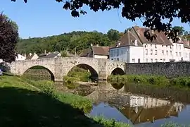 The Romanesque bridge in Chambon-sur-Voueize | |
 Coat of arms | |
Location of Chambon-sur-Voueize 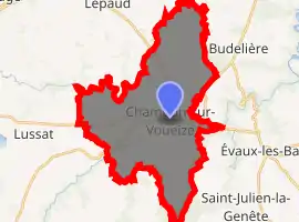
| |
 Chambon-sur-Voueize  Chambon-sur-Voueize | |
| Coordinates: 46°11′24″N 2°25′33″E | |
| Country | France |
| Region | Nouvelle-Aquitaine |
| Department | Creuse |
| Arrondissement | Aubusson |
| Canton | Évaux-les-Bains |
| Intercommunality | CC Creuse Confluence |
| Government | |
| • Mayor (2008–2014) | Cécile Creuzon |
| Area 1 | 33.58 km2 (12.97 sq mi) |
| Population (2017-01-01)[1] | 892 |
| • Density | 27/km2 (69/sq mi) |
| Time zone | UTC+01:00 (CET) |
| • Summer (DST) | UTC+02:00 (CEST) |
| INSEE/Postal code | 23045 /23170 |
| Elevation | 320–510 m (1,050–1,670 ft) |
| 1 French Land Register data, which excludes lakes, ponds, glaciers > 1 km2 (0.386 sq mi or 247 acres) and river estuaries. | |
Geography
An area of lakes, forestry and farming comprising a small town and several hamlets, situated at the confluence of the rivers Voueize and Tardes, some 10 miles (16 km) southwest of Montlucon near the junction of the D915, D917 and the D993 roads.
Population
| Year | Pop. | ±% |
|---|---|---|
| 1962 | 1,276 | — |
| 1968 | 1,367 | +7.1% |
| 1975 | 1,206 | −11.8% |
| 1982 | 1,288 | +6.8% |
| 1990 | 1,105 | −14.2% |
| 1999 | 1,012 | −8.4% |
| 2008 | 1,014 | +0.2% |
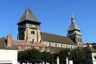
The church of Sainte-Valérie
Sights
See also
References
- "Populations légales 2017". INSEE. Retrieved 6 January 2020.
External links
| Wikimedia Commons has media related to Chambon-sur-Voueize. |
| Authority control |
|---|
This article is issued from Wikipedia. The text is licensed under Creative Commons - Attribution - Sharealike. Additional terms may apply for the media files.