Royère-de-Vassivière
Royère-de-Vassivière is a commune in the Creuse department in the Nouvelle-Aquitaine region in central France.
Royère-de-Vassivière | |
|---|---|
 | |
 Coat of arms | |
Location of Royère-de-Vassivière 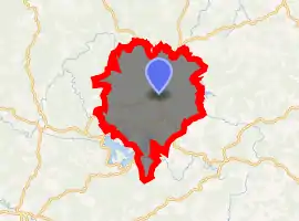
| |
 Royère-de-Vassivière  Royère-de-Vassivière | |
| Coordinates: 45°50′31″N 1°54′43″E | |
| Country | France |
| Region | Nouvelle-Aquitaine |
| Department | Creuse |
| Arrondissement | Guéret |
| Canton | Felletin |
| Intercommunality | CC Creuse Sud Ouest |
| Government | |
| • Mayor (2008–2014) | Raymond Rabeteau |
| Area 1 | 74.14 km2 (28.63 sq mi) |
| Population (2017-01-01)[1] | 575 |
| • Density | 7.8/km2 (20/sq mi) |
| Time zone | UTC+01:00 (CET) |
| • Summer (DST) | UTC+02:00 (CEST) |
| INSEE/Postal code | 23165 /23460 |
| Elevation | 540–829 m (1,772–2,720 ft) |
| 1 French Land Register data, which excludes lakes, ponds, glaciers > 1 km2 (0.386 sq mi or 247 acres) and river estuaries. | |
Geography
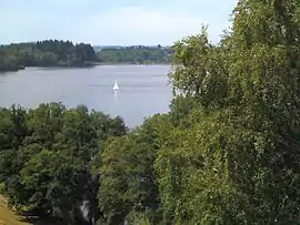
A large area of forestry, farming and lakes comprising the village and several hamlets situated some 17 miles (27 km) south of Aubusson on the D3, D7, D8 and the D59 roads. The rivers Maulde and Thaurion rise within the borders of the commune.
The commune lies within the regional park of the Millevaches, an area of the 1000 sources, not cows.
Population
| Year | Pop. | ±% |
|---|---|---|
| 1962 | 831 | — |
| 1968 | 771 | −7.2% |
| 1975 | 744 | −3.5% |
| 1982 | 782 | +5.1% |
| 1990 | 670 | −14.3% |
| 1999 | 636 | −5.1% |
| 2008 | 566 | −11.0% |
Sights
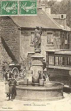
The Ceres fountain in 1919
- The church of St. Germain, dating from the thirteenth century.
- The Ceres fountain, opposite the church.
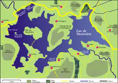
- The Lac de Vassiviere.
- The Lac de Lavaud-Gelade.
- The Modern Art Centre on the l'île de Vassivière.
- The Sculpture Park: 30 monumental sculptures by French and oversees artists.
References
- "Populations légales 2017". INSEE. Retrieved 6 January 2020.
External links
| Wikimedia Commons has media related to Royère-de-Vassivière. |
| Authority control |
|---|
This article is issued from Wikipedia. The text is licensed under Creative Commons - Attribution - Sharealike. Additional terms may apply for the media files.