Saint-Léger-le-Guérétois
Saint-Léger-le-Guérétois (Limousin: Sent Legèr (Garaitós)) is a commune in the Creuse department in central France.
Saint-Léger-le-Guérétois | |
|---|---|
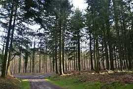 The forest of Maupuy | |
Location of Saint-Léger-le-Guérétois 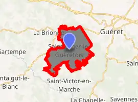
| |
 Saint-Léger-le-Guérétois  Saint-Léger-le-Guérétois | |
| Coordinates: 46°09′07″N 1°48′52″E | |
| Country | France |
| Region | Nouvelle-Aquitaine |
| Department | Creuse |
| Arrondissement | Guéret |
| Canton | Saint-Vaury |
| Intercommunality | CA Grand Guéret |
| Government | |
| • Mayor (2008–2014) | Patrick Rougeot |
| Area 1 | 13.98 km2 (5.40 sq mi) |
| Population (2017-01-01)[1] | 429 |
| • Density | 31/km2 (79/sq mi) |
| Time zone | UTC+01:00 (CET) |
| • Summer (DST) | UTC+02:00 (CEST) |
| INSEE/Postal code | 23208 /23000 |
| Elevation | 427–683 m (1,401–2,241 ft) (avg. 522 m or 1,713 ft) |
| 1 French Land Register data, which excludes lakes, ponds, glaciers > 1 km2 (0.386 sq mi or 247 acres) and river estuaries. | |
Population
| Year | Pop. | ±% |
|---|---|---|
| 1962 | 305 | — |
| 1968 | 353 | +15.7% |
| 1975 | 342 | −3.1% |
| 1982 | 385 | +12.6% |
| 1990 | 446 | +15.8% |
| 1999 | 425 | −4.7% |
| 2008 | 417 | −1.9% |
See also
References
- "Populations légales 2017". INSEE. Retrieved 6 January 2020.
| Wikimedia Commons has media related to Saint-Léger-le-Guérétois. |
| Authority control |
|---|
This article is issued from Wikipedia. The text is licensed under Creative Commons - Attribution - Sharealike. Additional terms may apply for the media files.
