Chéniers
Chéniers is a commune in the Creuse department in the Nouvelle-Aquitaine region in central France.
Chéniers | |
|---|---|
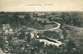 A general view of Chéniers, around 1920 | |
.svg.png.webp) Coat of arms | |
Location of Chéniers 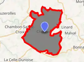
| |
 Chéniers  Chéniers | |
| Coordinates: 46°21′06″N 1°49′42″E | |
| Country | France |
| Region | Nouvelle-Aquitaine |
| Department | Creuse |
| Arrondissement | Guéret |
| Canton | Bonnat |
| Intercommunality | CC Pays Dunois |
| Government | |
| • Mayor (2008–2014) | Gilles Gaudon |
| Area 1 | 34.9 km2 (13.5 sq mi) |
| Population (2017-01-01)[1] | 572 |
| • Density | 16/km2 (42/sq mi) |
| Time zone | UTC+01:00 (CET) |
| • Summer (DST) | UTC+02:00 (CEST) |
| INSEE/Postal code | 23062 /23220 |
| Elevation | 230–384 m (755–1,260 ft) (avg. 277 m or 909 ft) |
| 1 French Land Register data, which excludes lakes, ponds, glaciers > 1 km2 (0.386 sq mi or 247 acres) and river estuaries. | |
Geography
An area of forestry and farming comprising the village and several hamlets, situated in the valley of the Petite Creuse river, some 12 miles (19 km) north of Guéret at the junction of the D46 and the D48 roads.
Population
| Year | Pop. | ±% |
|---|---|---|
| 1962 | 726 | — |
| 1968 | 837 | +15.3% |
| 1975 | 706 | −15.7% |
| 1982 | 684 | −3.1% |
| 1990 | 631 | −7.7% |
| 1999 | 583 | −7.6% |
| 2008 | 567 | −2.7% |
Sights
See also
References
- "Populations légales 2017". INSEE. Retrieved 6 January 2020.
| Wikimedia Commons has media related to Chéniers. |
This article is issued from Wikipedia. The text is licensed under Creative Commons - Attribution - Sharealike. Additional terms may apply for the media files.
