Sous-Parsat
Sous-Parsat is a commune in the Creuse department in the Nouvelle-Aquitaine region in central France.
Sous-Parsat | |
|---|---|
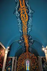 The decorated ceiling in the church | |
Location of Sous-Parsat 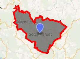
| |
 Sous-Parsat  Sous-Parsat | |
| Coordinates: 46°03′23″N 1°58′51″E | |
| Country | France |
| Region | Nouvelle-Aquitaine |
| Department | Creuse |
| Arrondissement | Guéret |
| Canton | Ahun |
| Intercommunality | CC Creuse Sud Ouest |
| Government | |
| • Mayor (2008–2014) | Michel Conchon |
| Area 1 | 9.14 km2 (3.53 sq mi) |
| Population (2017-01-01)[1] | 115 |
| • Density | 13/km2 (33/sq mi) |
| Time zone | UTC+01:00 (CET) |
| • Summer (DST) | UTC+02:00 (CEST) |
| INSEE/Postal code | 23175 /23150 |
| Elevation | 486–647 m (1,594–2,123 ft) (avg. 595 m or 1,952 ft) |
| 1 French Land Register data, which excludes lakes, ponds, glaciers > 1 km2 (0.386 sq mi or 247 acres) and river estuaries. | |
Geography
An area of lakes and streams, farming and forestry comprising the village and several hamlets situated some 12 miles (19 km) northwest of Aubusson, at the junction of the D17, D45 and the D60 roads.
Population
| Year | Pop. | ±% |
|---|---|---|
| 1962 | 179 | — |
| 1968 | 203 | +13.4% |
| 1975 | 191 | −5.9% |
| 1982 | 181 | −5.2% |
| 1990 | 155 | −14.4% |
| 1999 | 138 | −11.0% |
| 2008 | 150 | +8.7% |
Sights
- The ruins of a seventeenth-century church at Mareille-au-Prieur.
- 2 Roman columns.
- A washhouse and horse-trough at Le Pont.
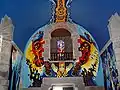
- The church, with parts dating from the twelfth century and paintings by Gabriel Chabrat realised between in the 1980s.
Apocalypse 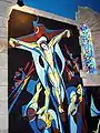
Crucifixion 
Flight to Egypt
See also
References
- "Populations légales 2017". INSEE. Retrieved 6 January 2020.
External links
| Wikimedia Commons has media related to Sous-Parsat. |
- The church paintings, by Chabrat (in French)
| Authority control |
|
|---|
This article is issued from Wikipedia. The text is licensed under Creative Commons - Attribution - Sharealike. Additional terms may apply for the media files.
