Chambonchard
Chambonchard is a commune in the Creuse department in the Nouvelle-Aquitaine region in central France.
Chambonchard | |
|---|---|
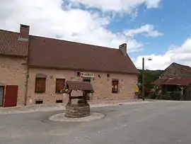 The town hall in Chambonchard | |
Location of Chambonchard 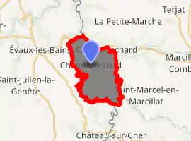
| |
 Chambonchard  Chambonchard | |
| Coordinates: 46°10′00″N 2°32′12″E | |
| Country | France |
| Region | Nouvelle-Aquitaine |
| Department | Creuse |
| Arrondissement | Aubusson |
| Canton | Évaux-les-Bains |
| Intercommunality | CC Creuse Confluence |
| Government | |
| • Mayor (2008–2014) | Gérard Rouffet |
| Area 1 | 12.86 km2 (4.97 sq mi) |
| Population (2017-01-01)[1] | 82 |
| • Density | 6.4/km2 (17/sq mi) |
| Time zone | UTC+01:00 (CET) |
| • Summer (DST) | UTC+02:00 (CEST) |
| INSEE/Postal code | 23046 /23110 |
| Elevation | 310–518 m (1,017–1,699 ft) |
| 1 French Land Register data, which excludes lakes, ponds, glaciers > 1 km2 (0.386 sq mi or 247 acres) and river estuaries. | |
Geography
An area of lakes, forestry and farming comprising a small village and several hamlets, situated by the banks of the river Cher, the border with the département of Allier, some 12 miles (19 km) south of Montlucon at the junction of the D20, D25 and the D915 roads.
Population
| Year | Pop. | ±% |
|---|---|---|
| 1962 | 164 | — |
| 1968 | 175 | +6.7% |
| 1975 | 155 | −11.4% |
| 1982 | 129 | −16.8% |
| 1990 | 116 | −10.1% |
| 1999 | 84 | −27.6% |
| 2008 | 84 | +0.0% |
Sights
- The church of St. Martin, dating from the twelfth century.
- The medieval castle of Ligondeix.
See also
References
- "Populations légales 2017". INSEE. Retrieved 6 January 2020.
| Wikimedia Commons has media related to Chambonchard. |
| Authority control |
|---|
This article is issued from Wikipedia. The text is licensed under Creative Commons - Attribution - Sharealike. Additional terms may apply for the media files.
