Le Monteil-au-Vicomte
Le Monteil-au-Vicomte is a commune in the Creuse department in the Nouvelle-Aquitaine region in central France.
Le Monteil-au-Vicomte | |
|---|---|
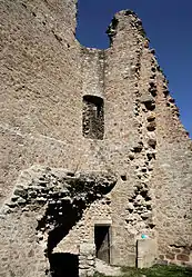 Ruins of the chateau | |
Location of Le Monteil-au-Vicomte 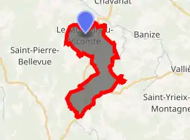
| |
 Le Monteil-au-Vicomte  Le Monteil-au-Vicomte | |
| Coordinates: 45°55′52″N 1°56′16″E | |
| Country | France |
| Region | Nouvelle-Aquitaine |
| Department | Creuse |
| Arrondissement | Guéret |
| Canton | Felletin |
| Intercommunality | CC Creuse Sud Ouest |
| Government | |
| • Mayor (2008–2014) | Christian Meyer |
| Area 1 | 14.4 km2 (5.6 sq mi) |
| Population (2017-01-01)[1] | 201 |
| • Density | 14/km2 (36/sq mi) |
| Time zone | UTC+01:00 (CET) |
| • Summer (DST) | UTC+02:00 (CEST) |
| INSEE/Postal code | 23134 /23460 |
| Elevation | 505–683 m (1,657–2,241 ft) |
| 1 French Land Register data, which excludes lakes, ponds, glaciers > 1 km2 (0.386 sq mi or 247 acres) and river estuaries. | |
Geography
An area of lakes, forestry and farming comprising a small village and several hamlets, situated by the banks of the Thaurion river, some 12 miles (19 km) west of Aubusson, at the junction of the D3, D36 and the D37 roads. The commune is within the boundaries of the natural park of the Millevaches (1000 lakes, not cows).
Population
| Year | Pop. | ±% |
|---|---|---|
| 1962 | 273 | — |
| 1968 | 289 | +5.9% |
| 1975 | 281 | −2.8% |
| 1982 | 287 | +2.1% |
| 1990 | 248 | −13.6% |
| 1999 | 266 | +7.3% |
| 2008 | 226 | −15.0% |
Sights
Personalities
- Pierre d'Aubusson (1423 - 30 June 1503), Grand Master of the order of St. John of Jerusalem (the Knights Hospitaller) was born at the castle.
See also
References
- "Populations légales 2017". INSEE. Retrieved 6 January 2020.
| Wikimedia Commons has media related to Le Monteil-au-Vicomte. |
| Authority control |
|---|
This article is issued from Wikipedia. The text is licensed under Creative Commons - Attribution - Sharealike. Additional terms may apply for the media files.