Fontanières
Fontanières is a commune in the Creuse department in the Nouvelle-Aquitaine region in central France.
Fontanières | |
|---|---|
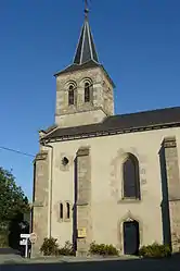 The Church of Our Lady of the Road, in Fontanières | |
Location of Fontanières 
| |
 Fontanières  Fontanières | |
| Coordinates: 46°06′34″N 2°30′05″E | |
| Country | France |
| Region | Nouvelle-Aquitaine |
| Department | Creuse |
| Arrondissement | Aubusson |
| Canton | Évaux-les-Bains |
| Intercommunality | CC Marche et Combraille en Aquitaine |
| Government | |
| • Mayor (2008–2014) | Maryse Breschard |
| Area 1 | 15.91 km2 (6.14 sq mi) |
| Population (2017-01-01)[1] | 249 |
| • Density | 16/km2 (41/sq mi) |
| Time zone | UTC+01:00 (CET) |
| • Summer (DST) | UTC+02:00 (CEST) |
| INSEE/Postal code | 23083 /23110 |
| Elevation | 390–575 m (1,280–1,886 ft) (avg. 548 m or 1,798 ft) |
| 1 French Land Register data, which excludes lakes, ponds, glaciers > 1 km2 (0.386 sq mi or 247 acres) and river estuaries. | |
Geography
A farming village and a couple of hamlets situated some 19 miles (31 km) northeast of Aubusson, at the junction of the D24, D25 and the D996 roads. The commune has an eastern border with the department of Allier and is served by a TER railway.
Population
| Year | Pop. | ±% |
|---|---|---|
| 1962 | 319 | — |
| 1968 | 361 | +13.2% |
| 1975 | 336 | −6.9% |
| 1982 | 277 | −17.6% |
| 1990 | 279 | +0.7% |
| 1999 | 259 | −7.2% |
| 2008 | 262 | +1.2% |
Sights
- The nineteenth-century church of Notre-Dame.
- A château in ruins at Salvert.
See also
References
- "Populations légales 2017". INSEE. Retrieved 6 January 2020.
| Wikimedia Commons has media related to Fontanières. |
| Authority control |
|---|
This article is issued from Wikipedia. The text is licensed under Creative Commons - Attribution - Sharealike. Additional terms may apply for the media files.
