Peyrat-la-Nonière
Peyrat-la-Nonière is a commune in the Creuse department in the Nouvelle-Aquitaine region in central France.
Peyrat-la-Nonière | |
|---|---|
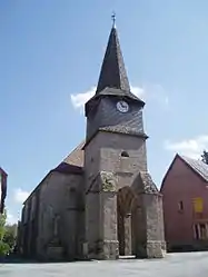 The church of Peyrat | |
 Coat of arms | |
Location of Peyrat-la-Nonière 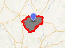
| |
 Peyrat-la-Nonière  Peyrat-la-Nonière | |
| Coordinates: 46°05′18″N 2°15′26″E | |
| Country | France |
| Region | Nouvelle-Aquitaine |
| Department | Creuse |
| Arrondissement | Aubusson |
| Canton | Gouzon |
| Intercommunality | CC Marche et Combraille en Aquitaine |
| Government | |
| • Mayor (2008–2014) | Guy de Lamberterie |
| Area 1 | 41.4 km2 (16.0 sq mi) |
| Population (2017-01-01)[1] | 426 |
| • Density | 10/km2 (27/sq mi) |
| Time zone | UTC+01:00 (CET) |
| • Summer (DST) | UTC+02:00 (CEST) |
| INSEE/Postal code | 23151 /23130 |
| Elevation | 409–556 m (1,342–1,824 ft) (avg. 450 m or 1,480 ft) |
| 1 French Land Register data, which excludes lakes, ponds, glaciers > 1 km2 (0.386 sq mi or 247 acres) and river estuaries. | |
Geography
An area of farming and forestry, lakes and streams comprising the village and several hamlets situated by the banks of the river Voueize, some 10 miles (16 km) north of Aubusson, at the junction of the D4, D54 and the D993 roads.
The river Tardes forms most of the commune's eastern border.
Population
| Year | Pop. | ±% |
|---|---|---|
| 1962 | 689 | — |
| 1968 | 786 | +14.1% |
| 1975 | 663 | −15.6% |
| 1982 | 609 | −8.1% |
| 1990 | 506 | −16.9% |
| 1999 | 499 | −1.4% |
| 2008 | 467 | −6.4% |
Sights
- The church, dating from the twelfth century.
- The remains of the abbey de Bonlieu.
- The castle of Chiroux.
- The two châteaux, du Mazeau and la Voreille.
- A sixteenth-century chapel.
- An ancient stone bridge over the river Tardes.
See also
References
- "Populations légales 2017". INSEE. Retrieved 6 January 2020.
External links
- Official website of Peyrat-la-Nonière (in French)
| Wikimedia Commons has media related to Peyrat-la-Nonière. |
| Authority control |
|---|
This article is issued from Wikipedia. The text is licensed under Creative Commons - Attribution - Sharealike. Additional terms may apply for the media files.
