Saint-Priest, Creuse
Saint-Priest is a commune in the Creuse department in central France.
Saint-Priest | |
|---|---|
Location of Saint-Priest 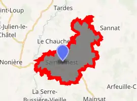
| |
 Saint-Priest  Saint-Priest | |
| Coordinates: 46°05′20″N 2°20′39″E | |
| Country | France |
| Region | Nouvelle-Aquitaine |
| Department | Creuse |
| Arrondissement | Aubusson |
| Canton | Évaux-les-Bains |
| Intercommunality | CC Marche et Combraille en Aquitaine |
| Government | |
| • Mayor (2008–2014) | Albert Bondieu |
| Area 1 | 22.34 km2 (8.63 sq mi) |
| Population (2017-01-01)[1] | 165 |
| • Density | 7.4/km2 (19/sq mi) |
| Time zone | UTC+01:00 (CET) |
| • Summer (DST) | UTC+02:00 (CEST) |
| INSEE/Postal code | 23234 /23110 |
| Elevation | 420–585 m (1,378–1,919 ft) (avg. 450 m or 1,480 ft) |
| 1 French Land Register data, which excludes lakes, ponds, glaciers > 1 km2 (0.386 sq mi or 247 acres) and river estuaries. | |
Geography
The river Tardes forms most of the commune's western border.
Population
| Year | Pop. | ±% |
|---|---|---|
| 1962 | 295 | — |
| 1968 | 351 | +19.0% |
| 1975 | 311 | −11.4% |
| 1982 | 258 | −17.0% |
| 1990 | 230 | −10.9% |
| 1999 | 192 | −16.5% |
| 2008 | 171 | −10.9% |
See also
References
- "Populations légales 2017". INSEE. Retrieved 6 January 2020.
| Wikimedia Commons has media related to Saint-Priest (Creuse). |
| Authority control |
|
|---|
This article is issued from Wikipedia. The text is licensed under Creative Commons - Attribution - Sharealike. Additional terms may apply for the media files.