La Celle-Dunoise
La-Celle-Dunoise is a commune in the Creuse department in the Nouvelle-Aquitaine region in central France.
La-Celle-Dunoise | |
|---|---|
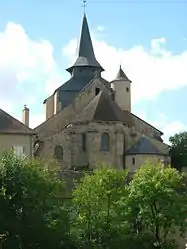 The church in La Celle-Dunoise | |
Location of La-Celle-Dunoise 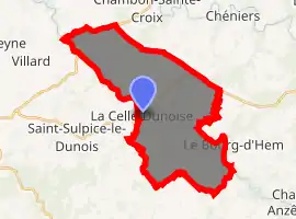
| |
 La-Celle-Dunoise  La-Celle-Dunoise | |
| Coordinates: 46°18′38″N 1°46′15″E | |
| Country | France |
| Region | Nouvelle-Aquitaine |
| Department | Creuse |
| Arrondissement | Guéret |
| Canton | Dun-le-Palestel |
| Intercommunality | CC Pays Dunois |
| Government | |
| • Mayor (2008–2014) | Jean-Marie Sachet |
| Area 1 | 29.11 km2 (11.24 sq mi) |
| Population (2017-01-01)[1] | 542 |
| • Density | 19/km2 (48/sq mi) |
| Time zone | UTC+01:00 (CET) |
| • Summer (DST) | UTC+02:00 (CEST) |
| INSEE/Postal code | 23039 /23800 |
| Elevation | 216–392 m (709–1,286 ft) (avg. 235 m or 771 ft) |
| 1 French Land Register data, which excludes lakes, ponds, glaciers > 1 km2 (0.386 sq mi or 247 acres) and river estuaries. | |
Geography
A very picturesque farming and quarrying village situated some 12 miles (19 km) northwest of Guéret, at the junction of the D15 and the D22, by the banks of the river Creuse.
History
La Celle-Dunoise has Gallo-Roman origins, as shown by various relics discovered within the territory of the commune.
In 1154, a document mentions the name of Ecclesia Cella, which by 1339 had become Ecclesia de Cella dunensi, giving the name of the village today.
A castle was built here in the 12th century but It was destroyed in 1500. It belonged to the family of La Celle, one of the most powerful families of La Marche in the Middle Ages.
Population
| Year | Pop. | ±% |
|---|---|---|
| 1962 | 862 | — |
| 1968 | 880 | +2.1% |
| 1975 | 732 | −16.8% |
| 1982 | 668 | −8.7% |
| 1990 | 589 | −11.8% |
| 1999 | 598 | +1.5% |
| 2008 | 607 | +1.5% |
Sights
- The church of St. Pierre, dating from the twelfth century.
- The bridge, dating from the fourteenth century.
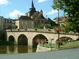
Bridge at La-Celle-Dunoise
See also
References
- "Populations légales 2017". INSEE. Retrieved 6 January 2020.
External links
| Wikimedia Commons has media related to La Celle-Dunoise. |
- Official commune website (in French)
- Website of the tourist office of the pays des 3 lacs (in French)
| Authority control |
|
|---|
This article is issued from Wikipedia. The text is licensed under Creative Commons - Attribution - Sharealike. Additional terms may apply for the media files.