Ahun
Ahun (Occitan: Aiun) is a commune in the Creuse department in the Nouvelle-Aquitaine region in central France.
Ahun | |
|---|---|
 The war memorial and the church of Saint-Sylvain, in Ahun | |
 Coat of arms | |
Location of Ahun 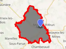
| |
 Ahun  Ahun | |
| Coordinates: 46°05′14″N 2°02′45″E | |
| Country | France |
| Region | Nouvelle-Aquitaine |
| Department | Creuse |
| Arrondissement | Guéret |
| Canton | Ahun |
| Intercommunality | Creuse Sud-Ouest |
| Government | |
| • Mayor (2020-2026) | Thierry Cotiche |
| Area 1 | 33.74 km2 (13.03 sq mi) |
| Population (2017-01-01)[1] | 1,432 |
| • Density | 42/km2 (110/sq mi) |
| Time zone | UTC+01:00 (CET) |
| • Summer (DST) | UTC+02:00 (CEST) |
| INSEE/Postal code | 23001 /23150 |
| Elevation | 331–564 m (1,086–1,850 ft) (avg. 449 m or 1,473 ft) |
| 1 French Land Register data, which excludes lakes, ponds, glaciers > 1 km2 (0.386 sq mi or 247 acres) and river estuaries. | |
Geography
A farming area comprising the village and several hamlets situated in the valley of the Creuse River, some 15 km (9.3 mi) southeast of Guéret, at the junction of the D942, D13 and the D18. It was the Roman site of Acitodunum, an important town on the route between Limoges and Clermont-Ferrand.
Population
| Year | Pop. | ±% |
|---|---|---|
| 2004 | 1,568 | — |
| 2006 | 1,560 | −0.5% |
| 2007 | 1,557 | −0.2% |
| 2008 | 1,568 | +0.7% |
| 2009 | 1,579 | +0.7% |
| 2010 | 1,590 | +0.7% |
| 2011 | 1,596 | +0.4% |
| 2012 | 1,528 | −4.3% |
| 2013 | 1,497 | −2.0% |
| 2014 | 1,466 | −2.1% |
| 2015 | 1,448 | −1.2% |
| 2016 | 1,438 | −0.7% |
Sights
- The viaduct carrying the railway 57m over the river, built by Lloyds and Nordling in 1864.
- The church of St.Sylvain, dating from the twelfth century.
- Three fifteenth century chateaux.
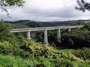
The railway viaduct at Busseau
Personalities
- Saint Silvanus of Ahun (Silvain), martyred and buried in the village.
- Jean Auclair, politician.
See also
References
- "Populations légales 2017". INSEE. Retrieved 6 January 2020.
External links
- Ahun on the Quid website (in French)
| Wikimedia Commons has media related to Ahun. |
| Authority control |
|
|---|
This article is issued from Wikipedia. The text is licensed under Creative Commons - Attribution - Sharealike. Additional terms may apply for the media files.
