Pontarion
Pontarion is a commune in the Creuse department in the Nouvelle-Aquitaine region in central France.
Pontarion | |
|---|---|
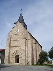 The church of Saint-Blaise, in Pontarion | |
 Coat of arms | |
Location of Pontarion 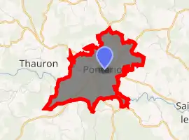
| |
 Pontarion  Pontarion | |
| Coordinates: 45°59′54″N 1°51′02″E | |
| Country | France |
| Region | Nouvelle-Aquitaine |
| Department | Creuse |
| Arrondissement | Guéret |
| Canton | Ahun |
| Intercommunality | CC Creuse Sud Ouest |
| Government | |
| • Mayor (2008–2014) | Jacky Guillon |
| Area 1 | 5.25 km2 (2.03 sq mi) |
| Population (2017-01-01)[1] | 365 |
| • Density | 70/km2 (180/sq mi) |
| Time zone | UTC+01:00 (CET) |
| • Summer (DST) | UTC+02:00 (CEST) |
| INSEE/Postal code | 23155 /23250 |
| Elevation | 435–561 m (1,427–1,841 ft) (avg. 443 m or 1,453 ft) |
| 1 French Land Register data, which excludes lakes, ponds, glaciers > 1 km2 (0.386 sq mi or 247 acres) and river estuaries. | |
Geography
A farming village situated by the banks of the river Thaurion, some 12 miles (19 km) south of Guéret, at the junction of the D13, D10, D940 and the D941.
Population
| Year | Pop. | ±% |
|---|---|---|
| 1962 | 418 | — |
| 1968 | 419 | +0.2% |
| 1975 | 388 | −7.4% |
| 1982 | 374 | −3.6% |
| 1990 | 350 | −6.4% |
| 1999 | 379 | +8.3% |
| 2008 | 357 | −5.8% |
Sights
- The church of St. Blaise, dating from the thirteenth century.
- The fifteenth-century château.
- The Maurice Lecante museum.
See also
References
- "Populations légales 2017". INSEE. Retrieved 6 January 2020.
| Wikimedia Commons has media related to Pontarion. |
| Authority control |
|
|---|
This article is issued from Wikipedia. The text is licensed under Creative Commons - Attribution - Sharealike. Additional terms may apply for the media files.
