Bonnat, Creuse
Bonnat is a commune in the Creuse department in the Nouvelle-Aquitaine region in France.
Bonnat | |
|---|---|
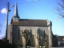 The church in Bonnat | |
 Coat of arms | |
Location of Bonnat 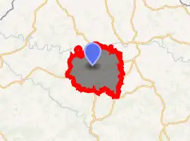
| |
 Bonnat  Bonnat | |
| Coordinates: 46°19′43″N 1°54′20″E | |
| Country | France |
| Region | Nouvelle-Aquitaine |
| Department | Creuse |
| Arrondissement | Guéret |
| Canton | Bonnat |
| Intercommunality | CC Portes de la Creuse en Marche |
| Government | |
| • Mayor (2020–2026) | Philippe Chavant |
| Area 1 | 45.79 km2 (17.68 sq mi) |
| Population | 1,315 |
| • Density | 29/km2 (74/sq mi) |
| Time zone | UTC+01:00 (CET) |
| • Summer (DST) | UTC+02:00 (CEST) |
| INSEE/Postal code | 23025 /23220 |
| Elevation | 248–515 m (814–1,690 ft) (avg. 354 m or 1,161 ft) |
| 1 French Land Register data, which excludes lakes, ponds, glaciers > 1 km2 (0.386 sq mi or 247 acres) and river estuaries. | |
Geography
An area of farming and some associated light industry, comprising the village and several hamlets situated in the valley of the Petite Creuse, some 10 miles (16 km) north of Guéret, at the junction of the D6, D15 and the D56.
Miscellany
The commune owns and manages a nearby chateau which has its own racing circuit for cars and motorbikes and is used for corporate functions. It also owns a restaurant in the town near to the church.
A small stream flows by the southern border of the town on which stands a recently renovated lavoir (wash-house).
A recent development of a very large book repository on land owned by the commune has caused some concern locally because of extensive lorry traffic on the narrow rural roads.
Population
| Year | Pop. | ±% |
|---|---|---|
| 1962 | 1,490 | — |
| 1968 | 1,535 | +3.0% |
| 1975 | 1,340 | −12.7% |
| 1982 | 1,348 | +0.6% |
| 1990 | 1,387 | +2.9% |
| 1999 | 1,348 | −2.8% |
| 2008 | 1,304 | −3.3% |
Sights
- The church of St. Sylvain, dating from the thirteenth century.
- An ancient public washhouse.
- Three chateaux.
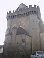 Fortifications of the church
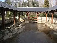 Recently restored Lavoir
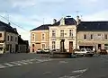 Village square
See also
References
- "Populations légales 2017". INSEE. Retrieved 6 January 2020.
| Wikimedia Commons has media related to Bonnat. |
| Authority control |
|---|