Blancafort, Cher
Blancafort is a commune in the Cher department in the Centre-Val de Loire region of France.
Blancafort | |
|---|---|
.JPG.webp) The Sauldre canal in Blancafort | |
.svg.png.webp) Coat of arms | |
Location of Blancafort 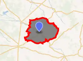
| |
 Blancafort  Blancafort | |
| Coordinates: 47°32′00″N 2°31′53″E | |
| Country | France |
| Region | Centre-Val de Loire |
| Department | Cher |
| Arrondissement | Vierzon |
| Canton | Aubigny-sur-Nère |
| Intercommunality | CC Sauldre et Sologne |
| Government | |
| • Mayor (2008–2014) | M. Margerin |
| Area 1 | 64.35 km2 (24.85 sq mi) |
| Population (2017-01-01)[1] | 1,038 |
| • Density | 16/km2 (42/sq mi) |
| Time zone | UTC+01:00 (CET) |
| • Summer (DST) | UTC+02:00 (CEST) |
| INSEE/Postal code | 18030 /18410 |
| Elevation | 162–261 m (531–856 ft) (avg. 175 m or 574 ft) |
| 1 French Land Register data, which excludes lakes, ponds, glaciers > 1 km2 (0.386 sq mi or 247 acres) and river estuaries. | |
Geography
A forestry and farming village situated in the valley of the river Sauldre, some 33 miles (53 km) north of Bourges at the junction of the D8, D30 and the D39 roads. The commune has a border with the department of Loiret. A canal was built here in the nineteenth century to ease drainage and provide transport links. The canal de Sauldre was last used commercially in the 1920s.
Population
| Year | Pop. | ±% |
|---|---|---|
| 1962 | 1,725 | — |
| 1968 | 1,735 | +0.6% |
| 1975 | 1,669 | −3.8% |
| 1982 | 972 | −41.8% |
| 1990 | 1,007 | +3.6% |
| 1999 | 936 | −7.1% |
| 2008 | 1,131 | +20.8% |
Sights
Museum of witchcraft
- The church of St. Andre, dating from the eleventh century.
- The twelfth-century chapel.
- The fifteenth-century chateau of Blancafort.
- The twelfth-century chateau de l'Hospital-du-Fresne.
- A museum of witchcraft.
- A public washhouse.
See also
References
- "Populations légales 2017". INSEE. Retrieved 6 January 2020.
External links
| Wikimedia Commons has media related to Blancafort. |
| Authority control |
|
|---|
This article is issued from Wikipedia. The text is licensed under Creative Commons - Attribution - Sharealike. Additional terms may apply for the media files.