Plou, Cher
Plou is a commune in the Cher département in the Centre-Val de Loire region of France.
Plou | |
|---|---|
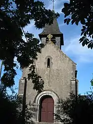 The church in Plou | |
Location of Plou 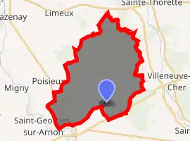
| |
 Plou  Plou | |
| Coordinates: 47°00′55″N 2°09′20″E | |
| Country | France |
| Region | Centre-Val de Loire |
| Department | Cher |
| Arrondissement | Bourges |
| Canton | Chârost |
| Intercommunality | Fercher - Pays florentais |
| Government | |
| • Mayor (2008–2014) | Fabrice Chabance |
| Area 1 | 33.21 km2 (12.82 sq mi) |
| Population (2017-01-01)[1] | 529 |
| • Density | 16/km2 (41/sq mi) |
| Time zone | UTC+01:00 (CET) |
| • Summer (DST) | UTC+02:00 (CEST) |
| INSEE/Postal code | 18181 /18290 |
| Elevation | 122–161 m (400–528 ft) (avg. 152 m or 499 ft) |
| 1 French Land Register data, which excludes lakes, ponds, glaciers > 1 km2 (0.386 sq mi or 247 acres) and river estuaries. | |
Geography
An area of farming and forestry comprising a small village and several hamlets situated some 13 miles (21 km) southwest of Bourges, at the junction of the D190, D114 and the D16e roads.
Population
| Year | Pop. | ±% |
|---|---|---|
| 1962 | 364 | — |
| 1968 | 421 | +15.7% |
| 1975 | 469 | +11.4% |
| 1982 | 410 | −12.6% |
| 1990 | 436 | +6.3% |
| 1999 | 436 | +0.0% |
| 2008 | 459 | +5.3% |
Sights
- The church of St. Pierre, originally from the 11th century, was partly reconstructed after the English occupation during the Hundred Years' War. The interior wooden vaults date from the 11th century.
- The ruins of a 14th-century castle, the Château de Font-Moreau.
- The château of Castelnau at Brouillamnon was originally a wooden castle, rebuilt in stone around 1100. It was transformed into a Renaissance home in 1541. In its present form, it dates from the 18th century.
Personalities
- Théophile Marion Dumersan, dramatist, was born here on 4 January 1780.
References
- "Populations légales 2017". INSEE. Retrieved 6 January 2020.
| Wikimedia Commons has media related to Plou. |
| Authority control |
|---|
This article is issued from Wikipedia. The text is licensed under Creative Commons - Attribution - Sharealike. Additional terms may apply for the media files.