Sidiailles
Sidiailles is a commune in the Cher department in the Centre-Val de Loire region of France.
Sidiailles | |
|---|---|
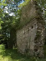 Ruins of the abbey | |
Location of Sidiailles 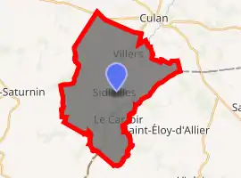
| |
 Sidiailles  Sidiailles | |
| Coordinates: 46°30′29″N 2°19′11″E | |
| Country | France |
| Region | Centre-Val de Loire |
| Department | Cher |
| Arrondissement | Saint-Amand-Montrond |
| Canton | Châteaumeillant |
| Government | |
| • Mayor (2008–2014) | Sylvie Deriaud |
| Area 1 | 31.96 km2 (12.34 sq mi) |
| Population (2017-01-01)[1] | 303 |
| • Density | 9.5/km2 (25/sq mi) |
| Time zone | UTC+01:00 (CET) |
| • Summer (DST) | UTC+02:00 (CEST) |
| INSEE/Postal code | 18252 /18270 |
| Elevation | 233–366 m (764–1,201 ft) (avg. 350 m or 1,150 ft) |
| 1 French Land Register data, which excludes lakes, ponds, glaciers > 1 km2 (0.386 sq mi or 247 acres) and river estuaries. | |
Geography
An area of farming and forestry comprising the village and several hamlets situated at the confluence of the rivers Arnon and Joyeuse, about 13 miles (21 km) south of Bourges at the junction of the D997 with the D111 and D237 roads.
Population
| Year | Pop. | ±% |
|---|---|---|
| 1962 | 561 | — |
| 1968 | 584 | +4.1% |
| 1975 | 563 | −3.6% |
| 1982 | 487 | −13.5% |
| 1990 | 375 | −23.0% |
| 1999 | 331 | −11.7% |
| 2008 | 304 | −8.2% |
Sights

The lake at Sidiailles
- The ruins of a twelfth-century abbey.
- The church of St. Pierre and St. Paul, dating from the twelfth century, with a bell cast in 1235.
- A large reservoir.
See also
References
- "Populations légales 2017". INSEE. Retrieved 6 January 2020.
External links
| Wikimedia Commons has media related to Sidiailles. |
- Sidiailles website (in French)
- Annuaire Mairie website (in French)
| Authority control |
|---|
This article is issued from Wikipedia. The text is licensed under Creative Commons - Attribution - Sharealike. Additional terms may apply for the media files.