Saint-Pierre-les-Étieux
Saint-Pierre-les-Étieux is a commune in the Cher department in the Centre-Val de Loire region of France.
Saint-Pierre-les-Étieux | |
|---|---|
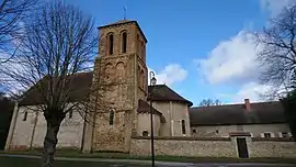 The church of Saint-Pierre, in Saint-Pierre-les-Étieux | |
.svg.png.webp) Coat of arms | |
Location of Saint-Pierre-les-Étieux 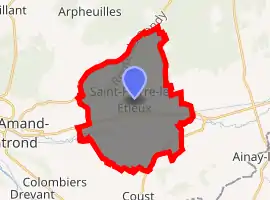
| |
 Saint-Pierre-les-Étieux  Saint-Pierre-les-Étieux | |
| Coordinates: 46°44′20″N 2°35′40″E | |
| Country | France |
| Region | Centre-Val de Loire |
| Department | Cher |
| Arrondissement | Saint-Amand-Montrond |
| Canton | Dun-sur-Auron |
| Intercommunality | CC Cœur de France |
| Government | |
| • Mayor (2008–2014) | Bertrand Desnoix |
| Area 1 | 27.34 km2 (10.56 sq mi) |
| Population (2017-01-01)[1] | 711 |
| • Density | 26/km2 (67/sq mi) |
| Time zone | UTC+01:00 (CET) |
| • Summer (DST) | UTC+02:00 (CEST) |
| INSEE/Postal code | 18231 /18210 |
| Elevation | 161–291 m (528–955 ft) (avg. 180 m or 590 ft) |
| 1 French Land Register data, which excludes lakes, ponds, glaciers > 1 km2 (0.386 sq mi or 247 acres) and river estuaries. | |
Geography
A farming area comprising the village and several hamlets situated by the banks of the small river Marmande and the canal de Berry, about 28 miles (45 km) southeast of Bourges near the junction of the D136 with the D6 and D951 roads.
Population
| Year | Pop. | ±% |
|---|---|---|
| 1962 | 784 | — |
| 1968 | 833 | +6.2% |
| 1975 | 692 | −16.9% |
| 1982 | 636 | −8.1% |
| 1990 | 759 | +19.3% |
| 1999 | 791 | +4.2% |
| 2008 | 733 | −7.3% |
Sights
- The church of St. Pierre, dating from the twelfth century.
- A fifteenth-century manorhouse.
- Two eighteenth-century houses.
- An old stone cross.
- A watermill.
See also
References
- "Populations légales 2017". INSEE. Retrieved 6 January 2020.
External links
| Wikimedia Commons has media related to Saint-Pierre-les-Étieux. |
- Annuaire Mairie website (in French)
| Authority control |
|---|
This article is issued from Wikipedia. The text is licensed under Creative Commons - Attribution - Sharealike. Additional terms may apply for the media files.