Santranges
Santranges is a commune in the Cher department in the Centre-Val de Loire region of France.
Santranges | |
|---|---|
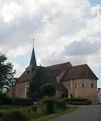 The church in Santranges | |
Location of Santranges 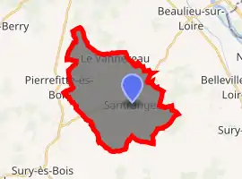
| |
 Santranges  Santranges | |
| Coordinates: 47°29′56″N 2°46′22″E | |
| Country | France |
| Region | Centre-Val de Loire |
| Department | Cher |
| Arrondissement | Bourges |
| Canton | Sancerre |
| Intercommunality | CC Pays Fort Sancerrois Val de Loire |
| Government | |
| • Mayor (2008–2014) | Francis Trochet |
| Area 1 | 24.31 km2 (9.39 sq mi) |
| Population (2017-01-01)[1] | 410 |
| • Density | 17/km2 (44/sq mi) |
| Time zone | UTC+01:00 (CET) |
| • Summer (DST) | UTC+02:00 (CEST) |
| INSEE/Postal code | 18243 /18240 |
| Elevation | 174–269 m (571–883 ft) (avg. 205 m or 673 ft) |
| 1 French Land Register data, which excludes lakes, ponds, glaciers > 1 km2 (0.386 sq mi or 247 acres) and river estuaries. | |
Geography
A large farming area comprising the village and several hamlets situated in the valleys of the rivers Avenelle and Notre-Heure, about 32 miles (51 km) northeast of Bourges, at the junction of the D926, D82 and the D54 roads. The commune borders the department of Loiret.
Population
| Year | Pop. | ±% |
|---|---|---|
| 1962 | 442 | — |
| 1968 | 514 | +16.3% |
| 1975 | 472 | −8.2% |
| 1982 | 420 | −11.0% |
| 1990 | 390 | −7.1% |
| 1999 | 369 | −5.4% |
| 2008 | 432 | +17.1% |
Sights
- The church of Notre-Dame, dating from the twelfth century.
See also
References
- "Populations légales 2017". INSEE. Retrieved 6 January 2020.
| Wikimedia Commons has media related to Santranges. |
| Authority control |
|---|
This article is issued from Wikipedia. The text is licensed under Creative Commons - Attribution - Sharealike. Additional terms may apply for the media files.