Touchay
Touchay is a commune in the Cher department in the Centre-Val de Loire region of France.
Touchay | |
|---|---|
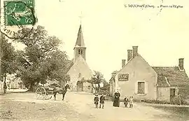 An old postcard view of the church of Saint-Martin, in Touchay, circa. 1900 | |
Location of Touchay 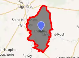
| |
 Touchay  Touchay | |
| Coordinates: 46°42′47″N 2°12′45″E | |
| Country | France |
| Region | Centre-Val de Loire |
| Department | Cher |
| Arrondissement | Saint-Amand-Montrond |
| Canton | Châteaumeillant |
| Government | |
| • Mayor (2008–2014) | Marylin Brossat |
| Area 1 | 23.41 km2 (9.04 sq mi) |
| Population (2017-01-01)[1] | 262 |
| • Density | 11/km2 (29/sq mi) |
| Time zone | UTC+01:00 (CET) |
| • Summer (DST) | UTC+02:00 (CEST) |
| INSEE/Postal code | 18266 /18160 |
| Elevation | 161–246 m (528–807 ft) (avg. 245 m or 804 ft) |
| 1 French Land Register data, which excludes lakes, ponds, glaciers > 1 km2 (0.386 sq mi or 247 acres) and river estuaries. | |
Geography
A farming area comprising the village and several hamlets situated on the banks of the river Arnon, about 23 miles (37 km) southwest of Bourges on the D69 road.
Population
| Year | Pop. | ±% |
|---|---|---|
| 1962 | 322 | — |
| 1968 | 342 | +6.2% |
| 1975 | 286 | −16.4% |
| 1982 | 298 | +4.2% |
| 1990 | 286 | −4.0% |
| 1999 | 297 | +3.8% |
| 2008 | 287 | −3.4% |
Sights
- The church of St. Martin, dating from the fifteenth century.
- The fifteenth-century manorhouse de l’Asnerie.
- The fifteenth-century chateau of l'Isle-sur-Arnon.
Personalities
- Maurice Utrillo, artist, lived here and created a painting of the village square.
See also
References
- "Populations légales 2017". INSEE. Retrieved 6 January 2020.
External links
| Wikimedia Commons has media related to Touchay. |
- Annuaire Mairie website (in French)
| Authority control |
|---|
This article is issued from Wikipedia. The text is licensed under Creative Commons - Attribution - Sharealike. Additional terms may apply for the media files.