Ourouer-les-Bourdelins
Ourouer-les-Bourdelins is a commune in the Cher department in the Centre-Val de Loire region of France.[2]
Ourouer-les-Bourdelins | |
|---|---|
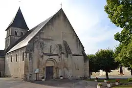 The church in Ourouer-les-Bourdelins | |
Location of Ourouer-les-Bourdelins 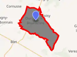
| |
 Ourouer-les-Bourdelins  Ourouer-les-Bourdelins | |
| Coordinates: 46°55′53″N 2°47′06″E | |
| Country | France |
| Region | Centre-Val de Loire |
| Department | Cher |
| Arrondissement | Saint-Amand-Montrond |
| Canton | La Guerche-sur-l'Aubois |
| Intercommunality | Pays de Nérondes |
| Government | |
| • Mayor (2008–2014) | Robert Belleret |
| Area 1 | 24.64 km2 (9.51 sq mi) |
| Population (2017-01-01)[1] | 615 |
| • Density | 25/km2 (65/sq mi) |
| Time zone | UTC+01:00 (CET) |
| • Summer (DST) | UTC+02:00 (CEST) |
| INSEE/Postal code | 18175 /18350 |
| Elevation | 173–256 m (568–840 ft) (avg. 210 m or 690 ft) |
| 1 French Land Register data, which excludes lakes, ponds, glaciers > 1 km2 (0.386 sq mi or 247 acres) and river estuaries. | |
Geography
A farming area comprising the village and a couple of hamlets situated some 21 miles (34 km) southeast of Bourges, at the junction of the D6 with the D15 and D109 roads. The river Airain forms all of the commune's northwestern boundary.
Population
| Year | Pop. | ±% |
|---|---|---|
| 1962 | 861 | — |
| 1968 | 893 | +3.7% |
| 1975 | 813 | −9.0% |
| 1982 | 758 | −6.8% |
| 1990 | 740 | −2.4% |
| 1999 | 667 | −9.9% |
| 2008 | 652 | −2.2% |
Sights
- The church of St. Christophe, dating from the twelfth century.[3]
- The fifteenth-century chateau.
See also
References
- "Populations légales 2017". INSEE. Retrieved 6 January 2020.
- "Commune d'Ourouer-les-Bourdelins (18175)" (in French). INSEE. Retrieved 2021-01-19.
- Base Mérimée: Eglise Saint-Christophe, Ministère français de la Culture. (in French)
External links
| Wikimedia Commons has media related to Ourouer-les-Bourdelins. |
- Annuaire Mairie website (in French)
| Authority control |
|---|
This article is issued from Wikipedia. The text is licensed under Creative Commons - Attribution - Sharealike. Additional terms may apply for the media files.