Subligny, Cher
Subligny is a commune in the Cher department in the Centre-Val de Loire region of France.
Subligny | |
|---|---|
.svg.png.webp) Coat of arms | |
Location of Subligny 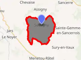
| |
 Subligny  Subligny | |
| Coordinates: 47°24′16″N 2°45′19″E | |
| Country | France |
| Region | Centre-Val de Loire |
| Department | Cher |
| Arrondissement | Bourges |
| Canton | Sancerre |
| Intercommunality | CC Pays Fort Sancerrois Val de Loire |
| Government | |
| • Mayor (2020–2026) | Régine Audry[1] |
| Area 1 | 17.26 km2 (6.66 sq mi) |
| Population (2017-01-01)[2] | 341 |
| • Density | 20/km2 (51/sq mi) |
| Time zone | UTC+01:00 (CET) |
| • Summer (DST) | UTC+02:00 (CEST) |
| INSEE/Postal code | 18256 /18260 |
| Elevation | 217–336 m (712–1,102 ft) (avg. 220 m or 720 ft) |
| 1 French Land Register data, which excludes lakes, ponds, glaciers > 1 km2 (0.386 sq mi or 247 acres) and river estuaries. | |
Geography
The commune occupies an area of forestry and farming comprising the village and a couple of hamlets situated in the valley of the river Salereine, about 26 miles (42 km) northeast of Bourges, at the junction of the D55 with the D57 and D152 roads.
Population
| Year | Pop. | ±% |
|---|---|---|
| 1962 | 344 | — |
| 1968 | 405 | +17.7% |
| 1975 | 360 | −11.1% |
| 1982 | 348 | −3.3% |
| 1990 | 320 | −8.0% |
| 1999 | 303 | −5.3% |
| 2008 | 355 | +17.2% |
Places of interest
- The church of St.Pierre and two chapels, dating from the fifteenth century.
- The sixteenth-century château de La Boulaye.
- An old tithe barn.
- A seventeenth-century stone cross in the cemetery.
See also
References
- "Répertoire national des élus: les maires". data.gouv.fr, Plateforme ouverte des données publiques françaises (in French). 2 December 2020. Retrieved 7 December 2020.
- "Populations légales 2017". INSEE. Retrieved 6 January 2020.
| Wikimedia Commons has media related to Subligny (Cher). |
| Authority control |
|---|
This article is issued from Wikipedia. The text is licensed under Creative Commons - Attribution - Sharealike. Additional terms may apply for the media files.