Saint-Palais, Cher
Saint-Palais is a commune in the Cher department in the Centre-Val de Loire region of France.
Saint-Palais | |
|---|---|
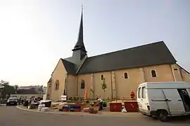 The church in Saint-Palais | |
 Coat of arms | |
Location of Saint-Palais 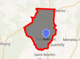
| |
 Saint-Palais  Saint-Palais | |
| Coordinates: 47°14′00″N 2°25′15″E | |
| Country | France |
| Region | Centre-Val de Loire |
| Department | Cher |
| Arrondissement | Bourges |
| Canton | Saint-Martin-d'Auxigny |
| Intercommunality | CC Terres du Haut Berry |
| Government | |
| • Mayor (2008–2014) | Bernard Ozon |
| Area 1 | 26.12 km2 (10.08 sq mi) |
| Population (2017-01-01)[1] | 619 |
| • Density | 24/km2 (61/sq mi) |
| Time zone | UTC+01:00 (CET) |
| • Summer (DST) | UTC+02:00 (CEST) |
| INSEE/Postal code | 18229 /18110 |
| Elevation | 164–310 m (538–1,017 ft) (avg. 230 m or 750 ft) |
| 1 French Land Register data, which excludes lakes, ponds, glaciers > 1 km2 (0.386 sq mi or 247 acres) and river estuaries. | |
Geography
An area of lakes, streams and farming comprising the village and a hamlet situated about 10 miles (16 km) north of Bourges, at the junction of the D940 with the D116 and the D170 roads.
Population
| Year | Pop. | ±% |
|---|---|---|
| 1962 | 511 | — |
| 1968 | 536 | +4.9% |
| 1975 | 486 | −9.3% |
| 1982 | 587 | +20.8% |
| 1990 | 602 | +2.6% |
| 1999 | 609 | +1.2% |
| 2008 | 626 | +2.8% |
Sights
- The church of St. Palais, dating from the twelfth century.
- The two chateaux, from the 14th and 16th century.
See also
References
- "Populations légales 2017". INSEE. Retrieved 6 January 2020.
| Wikimedia Commons has media related to Saint-Palais (Cher). |
| Authority control |
|---|
This article is issued from Wikipedia. The text is licensed under Creative Commons - Attribution - Sharealike. Additional terms may apply for the media files.