Savigny-en-Septaine
Savigny-en-Septaine is a commune in the Cher department in the Centre-Val de Loire region of France.
Savigny-en-Septaine | |
|---|---|
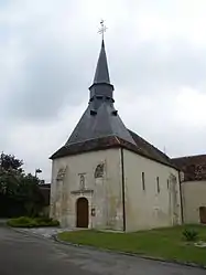 The church in Savigny-en-Septaine | |
.svg.png.webp) Coat of arms | |
Location of Savigny-en-Septaine 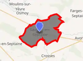
| |
 Savigny-en-Septaine  Savigny-en-Septaine | |
| Coordinates: 47°02′42″N 2°33′41″E | |
| Country | France |
| Region | Centre-Val de Loire |
| Department | Cher |
| Arrondissement | Bourges |
| Canton | Avord |
| Intercommunality | La Septaine |
| Government | |
| • Mayor (2008–2014) | Dominique Marcel |
| Area 1 | 22.58 km2 (8.72 sq mi) |
| Population (2017-01-01)[1] | 712 |
| • Density | 32/km2 (82/sq mi) |
| Time zone | UTC+01:00 (CET) |
| • Summer (DST) | UTC+02:00 (CEST) |
| INSEE/Postal code | 18247 /18390 |
| Elevation | 137–172 m (449–564 ft) (avg. 148 m or 486 ft) |
| 1 French Land Register data, which excludes lakes, ponds, glaciers > 1 km2 (0.386 sq mi or 247 acres) and river estuaries. | |
Geography
A farming area comprising a village and a few hamlets situated about 6 miles (9.7 km) southeast of Bourges, at the junction of the D976 with the D46 and the D66 roads. The village lies on the left bank of the river Airain, which flows north through the middle of the commune, then flows into the Yèvre, which forms part of the commune's northern boundary.
History
During the summer 1944, in a farm of the village occurred the Tragedy of the Guerry's wells. It designates the massacre of 36 Jews by French militiamen.
Population
| Year | Pop. | ±% |
|---|---|---|
| 1962 | 394 | — |
| 1968 | 449 | +14.0% |
| 1975 | 499 | +11.1% |
| 1982 | 546 | +9.4% |
| 1990 | 570 | +4.4% |
| 1999 | 622 | +9.1% |
| 2008 | 672 | +8.0% |
Sights
- The church of St. Etienne, dating from the thirteenth century.
- A watermill.
See also
References
- "Populations légales 2017". INSEE. Retrieved 6 January 2020.
External links
| Wikimedia Commons has media related to Savigny-en-Septaine. |
- Old postcard photos of the commune (in French)
- Unofficial commune website (in French)
| Authority control |
|
|---|
This article is issued from Wikipedia. The text is licensed under Creative Commons - Attribution - Sharealike. Additional terms may apply for the media files.