Sury-ès-Bois
Sury-ès-Bois is a commune in the Cher department in the Centre-Val de Loire region of France.
Sury-ès-Bois | |
|---|---|
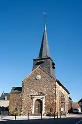 The church in Sury-ès-Bois | |
Location of Sury-ès-Bois 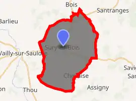
| |
 Sury-ès-Bois  Sury-ès-Bois | |
| Coordinates: 47°27′55″N 2°42′18″E | |
| Country | France |
| Region | Centre-Val de Loire |
| Department | Cher |
| Arrondissement | Bourges |
| Canton | Sancerre |
| Intercommunality | CC Pays Fort Sancerrois Val de Loire |
| Government | |
| • Mayor (2008–2014) | Jean-Claude Rimbault |
| Area 1 | 31.9 km2 (12.3 sq mi) |
| Population (2017-01-01)[1] | 270 |
| • Density | 8.5/km2 (22/sq mi) |
| Time zone | UTC+01:00 (CET) |
| • Summer (DST) | UTC+02:00 (CEST) |
| INSEE/Postal code | 18259 /18260 |
| Elevation | 200–336 m (656–1,102 ft) (avg. 263 m or 863 ft) |
| 1 French Land Register data, which excludes lakes, ponds, glaciers > 1 km2 (0.386 sq mi or 247 acres) and river estuaries. | |
Geography
A large farming area comprising the village and several hamlets situated at the border with the department of Loiret about 32 miles (51 km) northeast of Bourges at the junction of the D13, D926 and the D74 roads. The commune’s territory is the source of several small rivers.
Population
| Year | Pop. | ±% |
|---|---|---|
| 1962 | 452 | — |
| 1968 | 506 | +11.9% |
| 1975 | 423 | −16.4% |
| 1982 | 371 | −12.3% |
| 1990 | 350 | −5.7% |
| 1999 | 315 | −10.0% |
| 2008 | 290 | −7.9% |
Sights
- The church of St. Martin, dating from the fifteenth century.
- The manorhouse of l'Asnerie.
- Traces of the old priory of Saint-Anne.
- The thirteenth-century chapel of the chateau of Charpignon.
See also
References
- "Populations légales 2017". INSEE. Retrieved 6 January 2020.
| Wikimedia Commons has media related to Sury-ès-Bois. |
| Authority control |
|---|
This article is issued from Wikipedia. The text is licensed under Creative Commons - Attribution - Sharealike. Additional terms may apply for the media files.