Charenton-du-Cher
Charenton-du-Cher is a commune in the Cher department in the Centre-Val de Loire region of France.
Charenton-du-Cher | |
|---|---|
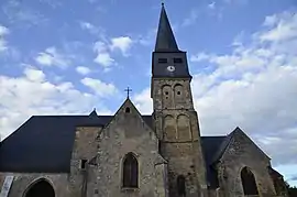 The church in Charenton-du-Cher | |
 Coat of arms | |
Location of Charenton-du-Cher 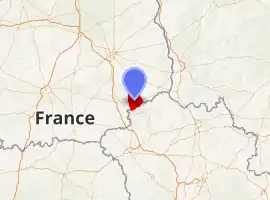
| |
 Charenton-du-Cher  Charenton-du-Cher | |
| Coordinates: 46°43′50″N 2°38′35″E | |
| Country | France |
| Region | Centre-Val de Loire |
| Department | Cher |
| Arrondissement | Saint-Amand-Montrond |
| Canton | Dun-sur-Auron |
| Intercommunality | CC Cœur de France |
| Government | |
| • Mayor (2008–2014) | Pascal Aupy |
| Area 1 | 4,789 km2 (1,849 sq mi) |
| Population | 1,045 |
| • Density | 0.22/km2 (0.57/sq mi) |
| Time zone | UTC+01:00 (CET) |
| • Summer (DST) | UTC+02:00 (CEST) |
| INSEE/Postal code | 18052 /18210 |
| Elevation | 167–253 m (548–830 ft) (avg. 178 m or 584 ft) |
| 1 French Land Register data, which excludes lakes, ponds, glaciers > 1 km2 (0.386 sq mi or 247 acres) and river estuaries. | |
Geography
An area of farming, forestry and a little light industry comprising the village and several hamlets situated by the banks of both the canal de Berry and the river Marmande, some 28 miles (45 km) southeast of Bourges at the junction of the D951 with the D1 and D953 roads.
Population
| Year | Pop. | ±% |
|---|---|---|
| 1962 | 1,362 | — |
| 1968 | 1,372 | +0.7% |
| 1975 | 1,371 | −0.1% |
| 1982 | 1,292 | −5.8% |
| 1990 | 1,154 | −10.7% |
| 1999 | 1,096 | −5.0% |
| 2008 | 1,119 | +2.1% |
Sights
- The church of St. Martin, dating from the eleventh century.
- The motte of a tenth-century castle (30m diameter, 10m high).
- A fifteenth-century house on the rue Blanche.
- An old forge and its associated buildings, La "Grosse Forge"
- Remains of the convent abbey of Notre-Dame de Bellevaux, founded in 620.
- The remains of the 15th century chapel of St. Julien.
- A public washhouse.
See also
References
- "Populations légales 2017". INSEE. Retrieved 6 January 2020.
| Wikimedia Commons has media related to Charenton-du-Cher. |
| Authority control |
|
|---|
This article is issued from Wikipedia. The text is licensed under Creative Commons - Attribution - Sharealike. Additional terms may apply for the media files.