Saint-Loup-des-Chaumes
Saint-Loup-des-Chaumes is a commune in the Cher department in the Centre-Val de Loire region of France.
Saint-Loup-des-Chaumes | |
|---|---|
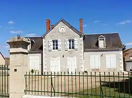 The old town hall in Saint-Loup-des-Chaumes | |
Location of Saint-Loup-des-Chaumes 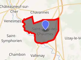
| |
 Saint-Loup-des-Chaumes  Saint-Loup-des-Chaumes | |
| Coordinates: 46°49′31″N 2°23′24″E | |
| Country | France |
| Region | Centre-Val de Loire |
| Department | Cher |
| Arrondissement | Saint-Amand-Montrond |
| Canton | Trouy |
| Intercommunality | CC Arnon Boischaut Cher |
| Government | |
| • Mayor (2008–2014) | Philippe Moisson |
| Area 1 | 18.55 km2 (7.16 sq mi) |
| Population (2017-01-01)[1] | 299 |
| • Density | 16/km2 (42/sq mi) |
| Time zone | UTC+01:00 (CET) |
| • Summer (DST) | UTC+02:00 (CEST) |
| INSEE/Postal code | 18221 /18190 |
| Elevation | 133–177 m (436–581 ft) (avg. 200 m or 660 ft) |
| 1 French Land Register data, which excludes lakes, ponds, glaciers > 1 km2 (0.386 sq mi or 247 acres) and river estuaries. | |
Geography
An area of lakes, streams and farming comprising the village and two hamlets situated on the banks of the river Cher some 18 miles (29 km) south of Bourges at the junction of the D3 with the D35 and the D37 roads. The A71 autoroute passes through the eastern side of the commune.
Population
| Year | Pop. | ±% |
|---|---|---|
| 1962 | 326 | — |
| 1968 | 345 | +5.8% |
| 1975 | 322 | −6.7% |
| 1982 | 302 | −6.2% |
| 1990 | 278 | −7.9% |
| 1999 | 277 | −0.4% |
| 2008 | 290 | +4.7% |
Sights
See also
References
- "Populations légales 2017". INSEE. Retrieved 6 January 2020.
External links
| Wikimedia Commons has media related to Saint-Loup-des-Chaumes. |
- Annuaire Mairie website (in French)
| Authority control |
|---|
This article is issued from Wikipedia. The text is licensed under Creative Commons - Attribution - Sharealike. Additional terms may apply for the media files.