Saint-Satur
Saint-Satur is a commune in the Cher department in central France.
Saint-Satur | |
|---|---|
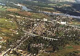 An aerial view of Saint-Satur | |
.svg.png.webp) Coat of arms | |
Location of Saint-Satur 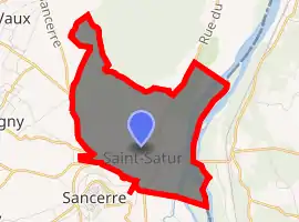
| |
 Saint-Satur  Saint-Satur | |
| Coordinates: 47°20′31″N 2°51′15″E | |
| Country | France |
| Region | Centre-Val de Loire |
| Department | Cher |
| Arrondissement | Bourges |
| Canton | Sancerre |
| Intercommunality | CC Pays Fort Sancerrois Val de Loire |
| Government | |
| • Mayor (2008–2014) | Guy Poubeau |
| Area 1 | 7.86 km2 (3.03 sq mi) |
| Population (2017-01-01)[1] | 1,426 |
| • Density | 180/km2 (470/sq mi) |
| Time zone | UTC+01:00 (CET) |
| • Summer (DST) | UTC+02:00 (CEST) |
| INSEE/Postal code | 18233 /18300 |
| Elevation | 144–273 m (472–896 ft) (avg. 180 m or 590 ft) |
| 1 French Land Register data, which excludes lakes, ponds, glaciers > 1 km2 (0.386 sq mi or 247 acres) and river estuaries. | |
It is a medieval town near the Loire River in the former province of Berry.
History
Located in the area of Gaul settled by the powerful Celtic tribe, the Bituriges, or the "Kings of the World", and after their defeat at Bourges (Avaricum), part of Roman Aquitania. Some evidence points to the existence of an early Roman river town of Gordona (Castle-Gordon), now Saint-Thibault and Saint-Satur; located on the Roman road (Gordaine) from Bourges to the Roman bridge over the Loire River in Saint-Thibault.
An Augustinian abbey was founded in Saint-Satur in 1034. During the Hundred Years' War, the Augustine Abbey was destroyed.
Area transportation was improved by the construction of a suspension bridge at Saint-Thibault (1834), the Canal latéral à la Loire (1838) and later, the Bourges - Sancerre - Cosne-sur-Loire railroad line (1885).
During World War II, Saint-Satur, with Sancerre, was a regional command center for the French Resistance. "Operation Spencer" in 1944 was to prevent the Germans from crossing the Loire River between Gien and Nevers and reinforcing troops in Brittany. The French Resistance and Free French Forces blew up the bridge at Saint-Thibault and sabotaged communication, road and railway lines.
Geography
In the south-eastern part of the commune, the river Vauvise flows into the Loire, which forms all of the commune's eastern boundary.
Population
| Year | Pop. | ±% |
|---|---|---|
| 1962 | 1,661 | — |
| 1968 | 1,759 | +5.9% |
| 1975 | 1,774 | +0.9% |
| 1982 | 1,961 | +10.5% |
| 1990 | 1,805 | −8.0% |
| 1999 | 1,731 | −4.1% |
| 2008 | 1,659 | −4.2% |
See also
References
- "Populations légales 2017". INSEE. Retrieved 6 January 2020.
| Wikimedia Commons has media related to Saint-Satur. |
| Authority control |
|
|---|