Ménétréol-sur-Sauldre
Ménétréol-sur-Sauldre is a commune in the Cher department in the Centre-Val de Loire region of France.
Ménétréol-sur-Sauldre | |
|---|---|
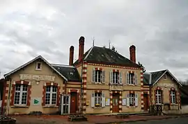 Town hall and school | |
Location of Ménétréol-sur-Sauldre 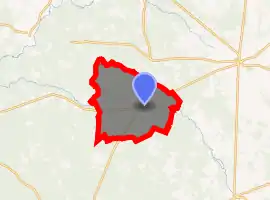
| |
 Ménétréol-sur-Sauldre  Ménétréol-sur-Sauldre | |
| Coordinates: 47°26′56″N 2°18′31″E | |
| Country | France |
| Region | Centre-Val de Loire |
| Department | Cher |
| Arrondissement | Vierzon |
| Canton | Aubigny-sur-Nère |
| Intercommunality | Sauldre et Sologne |
| Government | |
| • Mayor (2008–2014) | Patrick Violleau |
| Area 1 | 50.08 km2 (19.34 sq mi) |
| Population (2017-01-01)[1] | 212 |
| • Density | 4.2/km2 (11/sq mi) |
| Time zone | UTC+01:00 (CET) |
| • Summer (DST) | UTC+02:00 (CEST) |
| INSEE/Postal code | 18147 /18700 |
| Elevation | 131–183 m (430–600 ft) (avg. 152 m or 499 ft) |
| 1 French Land Register data, which excludes lakes, ponds, glaciers > 1 km2 (0.386 sq mi or 247 acres) and river estuaries. | |
Geography
An area of lakes, forestry and farming comprising the village and a hamlet situated in the valley of the petite Sauldre river, some 16 miles (26 km) north of Bourges at the junction of the D924, D12 and the D79 roads.
The Petite Sauldre flows westward through the middle of the commune; the village lies on its right bank. The Rère flows northwestward, then southwestward, through the heavily-wooded southern part of the commune.
Population
| Year | Pop. | ±% |
|---|---|---|
| 1962 | 230 | — |
| 1968 | 256 | +11.3% |
| 1975 | 250 | −2.3% |
| 1982 | 223 | −10.8% |
| 1990 | 229 | +2.7% |
| 1999 | 271 | +18.3% |
| 2008 | 252 | −7.0% |
Sights
- The church of St. Martin, dating from the nineteenth century.
- The remains of the castle of la Faye, dating from the thirteenth century.
See also
References
- "Populations légales 2017". INSEE. Retrieved 6 January 2020.
| Wikimedia Commons has media related to Ménétréol-sur-Sauldre. |
| Authority control |
|---|
This article is issued from Wikipedia. The text is licensed under Creative Commons - Attribution - Sharealike. Additional terms may apply for the media files.