Dun-sur-Auron
Dun-sur-Auron is a commune in the Cher department in the Centre-Val de Loire region of France.
Dun-sur-Auron | |
|---|---|
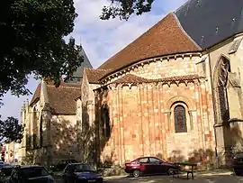 The church in Dun-sur-Auron | |
.svg.png.webp) Coat of arms | |
Location of Dun-sur-Auron 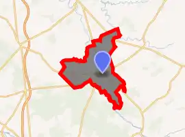
| |
 Dun-sur-Auron  Dun-sur-Auron | |
| Coordinates: 46°53′08″N 2°34′21″E | |
| Country | France |
| Region | Centre-Val de Loire |
| Department | Cher |
| Arrondissement | Saint-Amand-Montrond |
| Canton | Dun-sur-Auron |
| Intercommunality | CC Le Dunois |
| Government | |
| • Mayor (2008–2014) | Louis Cosyns |
| Area 1 | 50.09 km2 (19.34 sq mi) |
| Population (2017-01-01)[1] | 3,844 |
| • Density | 77/km2 (200/sq mi) |
| Time zone | UTC+01:00 (CET) |
| • Summer (DST) | UTC+02:00 (CEST) |
| INSEE/Postal code | 18087 /18130 |
| Elevation | 151–188 m (495–617 ft) (avg. 174 m or 571 ft) |
| 1 French Land Register data, which excludes lakes, ponds, glaciers > 1 km2 (0.386 sq mi or 247 acres) and river estuaries. | |
Geography
A farming area comprising a small town and a couple of hamlets situated by the banks of both the Auron River and the canal de Berry some 26 miles (42 km) east of Bourges at the junction of the D10, D14, D28, D34 and the D943 roads. Another small river, the Airain flows northwest through the northern part of the commune.
Population
| Year | Pop. | ±% |
|---|---|---|
| 1962 | 3,982 | — |
| 1968 | 3,995 | +0.3% |
| 1975 | 4,154 | +4.0% |
| 1982 | 4,238 | +2.0% |
| 1990 | 4,261 | +0.5% |
| 1999 | 4,013 | −5.8% |
| 2006 | 3,942 | −1.8% |
History
Dun-sur-Auron dates back from Dunum, a Gaul fortified place. In the Middle Ages it depended from the Vicecount of Bourges. In 1101, the last Vicecount, Eudes de Dun, sold his estates to King Philip I of France and the city was renamed Dun-le-roi.
Sights
- The sixteenth-century town walls
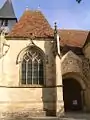
- The twelfth-century church of St. Etienne.
- Fifteenth-century houses.
- A feudal motte castle.
- The chateau of La Périsse.
- The belltower.
- A museum.
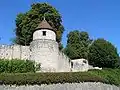 Walls and towers
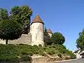 Fortifications
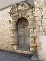 A gateway in the walls
 The church entrance
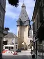 The bell tower
Personalities
- Maurice Bardèche (1907–1998), journalist and writer.
See also
References
- "Populations légales 2017". INSEE. Retrieved 6 January 2020.
External links
| Wikimedia Commons has media related to Dun-sur-Auron. |
- Official town website (in French)
| Authority control |
|---|
This article is issued from Wikipedia. The text is licensed under Creative Commons - Attribution - Sharealike. Additional terms may apply for the media files.