Savigny-en-Sancerre
Savigny-en-Sancerre is a commune in the Cher department in the Centre-Val de Loire region of France.
Savigny-en-Sancerre | |
|---|---|
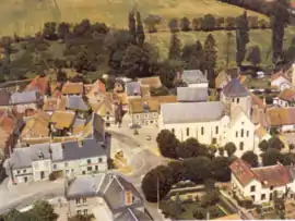 An aerial view of the church, the town hall and the main shops | |
.svg.png.webp) Coat of arms | |
Location of Savigny-en-Sancerre 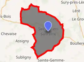
| |
 Savigny-en-Sancerre  Savigny-en-Sancerre | |
| Coordinates: 47°26′31″N 2°48′36″E | |
| Country | France |
| Region | Centre-Val de Loire |
| Department | Cher |
| Arrondissement | Bourges |
| Canton | Sancerre |
| Intercommunality | CC Pays Fort Sancerrois Val de Loire |
| Government | |
| • Mayor (2008–2014) | Thérèse Ruelle |
| Area 1 | 33.31 km2 (12.86 sq mi) |
| Population (2017-01-01)[1] | 1,030 |
| • Density | 31/km2 (80/sq mi) |
| Time zone | UTC+01:00 (CET) |
| • Summer (DST) | UTC+02:00 (CEST) |
| INSEE/Postal code | 18246 /18240 |
| Elevation | 176–298 m (577–978 ft) (avg. 226 m or 741 ft) |
| 1 French Land Register data, which excludes lakes, ponds, glaciers > 1 km2 (0.386 sq mi or 247 acres) and river estuaries. | |
Geography
A farming area comprising a village and several hamlets situated about 31 miles (50 km) northeast of Bourges, at the junction of the D13 with the D54, D47 and the D152 roads. The commune is the source of many small rivers.
Population
| Year | Pop. | ±% |
|---|---|---|
| 1962 | 872 | — |
| 1968 | 895 | +2.6% |
| 1975 | 855 | −4.5% |
| 1982 | 891 | +4.2% |
| 1990 | 981 | +10.1% |
| 1999 | 1,023 | +4.3% |
| 2008 | 1,080 | +5.6% |
Sights
- The church of St. Symphorien, dating from the twelfth century.
- The fifteenth-century chapel in the cemetery.
See also
References
- "Populations légales 2017". INSEE. Retrieved 6 January 2020.
| Wikimedia Commons has media related to Savigny-en-Sancerre. |
| Authority control |
|---|
This article is issued from Wikipedia. The text is licensed under Creative Commons - Attribution - Sharealike. Additional terms may apply for the media files.
