Méry-ès-Bois
Méry-ès-Bois is a commune in the Cher department in the Centre-Val de Loire region of France.
Méry-ès-Bois | |
|---|---|
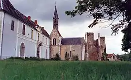 The Abbey of Loroy, in Méry-ès-Bois, in 1987 | |
Location of Méry-ès-Bois 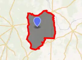
| |
 Méry-ès-Bois  Méry-ès-Bois | |
| Coordinates: 47°19′31″N 2°21′46″E | |
| Country | France |
| Region | Centre-Val de Loire |
| Department | Cher |
| Arrondissement | Vierzon |
| Canton | Aubigny-sur-Nère |
| Intercommunality | Sauldre et Sologne |
| Government | |
| • Mayor (2008–2014) | Michael Désir |
| Area 1 | 91.59 km2 (35.36 sq mi) |
| Population (2017-01-01)[1] | 577 |
| • Density | 6.3/km2 (16/sq mi) |
| Time zone | UTC+01:00 (CET) |
| • Summer (DST) | UTC+02:00 (CEST) |
| INSEE/Postal code | 18149 /18380 |
| Elevation | 171–293 m (561–961 ft) (avg. 250 m or 820 ft) |
| 1 French Land Register data, which excludes lakes, ponds, glaciers > 1 km2 (0.386 sq mi or 247 acres) and river estuaries. | |
Geography
A large area of streams, lakes, forestry and farming comprising the village and several hamlets situated some 16 miles (26 km) north of Bourges at the junction of the D22, D58 and the D168 roads and also on the D926 and D940. Two rivers have their source here, the Mocquart and the Guette and the Barangeon river flows through the middle of the commune.
Population
| Year | Pop. | ±% |
|---|---|---|
| 1962 | 771 | — |
| 1968 | 778 | +0.9% |
| 1975 | 708 | −9.0% |
| 1982 | 637 | −10.0% |
| 1990 | 659 | +3.5% |
| 1999 | 616 | −6.5% |
| 2008 | 614 | −0.3% |
Sights
- The church of St. Firmin, dating from the eleventh century.
- The thirteenth-century abbey of Loroy.
See also
References
- "Populations légales 2017". INSEE. Retrieved 6 January 2020.
| Wikimedia Commons has media related to Méry-ès-Bois. |
| Authority control |
|---|
This article is issued from Wikipedia. The text is licensed under Creative Commons - Attribution - Sharealike. Additional terms may apply for the media files.