Osmery
Osmery is a commune in the Cher department in the Centre-Val de Loire region of France.
Osmery | |
|---|---|
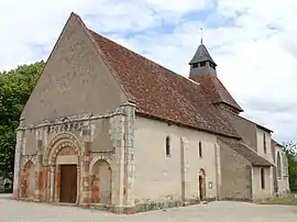 The church of Saint-Julien, in Osmery | |
Location of Osmery 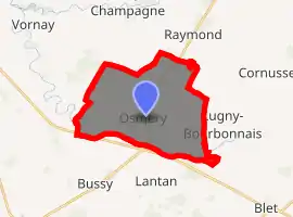
| |
 Osmery  Osmery | |
| Coordinates: 46°56′08″N 2°39′21″E | |
| Country | France |
| Region | Centre-Val de Loire |
| Department | Cher |
| Arrondissement | Saint-Amand-Montrond |
| Canton | Dun-sur-Auron |
| Intercommunality | CC Le Dunois |
| Government | |
| • Mayor (2008–2014) | Patrick de Brunier |
| Area 1 | 21.27 km2 (8.21 sq mi) |
| Population (2017-01-01)[1] | 263 |
| • Density | 12/km2 (32/sq mi) |
| Time zone | UTC+01:00 (CET) |
| • Summer (DST) | UTC+02:00 (CEST) |
| INSEE/Postal code | 18173 /18130 |
| Elevation | 161–199 m (528–653 ft) (avg. 169 m or 554 ft) |
| 1 French Land Register data, which excludes lakes, ponds, glaciers > 1 km2 (0.386 sq mi or 247 acres) and river estuaries. | |
Geography
A farming area comprising a village and several hamlets situated some 16 miles (26 km) southeast of Bourges, near the junction of the D10 with the D2076 and D166 roads. The village lies on the right bank of the Airain, which flows west-northwest through the southern part of the commune.
Population
| Year | Pop. | ±% |
|---|---|---|
| 1962 | 435 | — |
| 1968 | 419 | −3.7% |
| 1975 | 371 | −11.5% |
| 1982 | 309 | −16.7% |
| 1990 | 276 | −10.7% |
| 1999 | 254 | −8.0% |
| 2008 | 266 | +4.7% |
Sights
- The church of St. Julien, dating from the twelfth century
- The fifteenth-century chateau of Défens
- A seventeenth-century chapel
See also
References
- "Populations légales 2017". INSEE. Retrieved 6 January 2020.
External links
| Wikimedia Commons has media related to Osmery. |
- Annuaire Mairie website (in French)
- Osmery.fr (in French)
| Authority control |
|---|
This article is issued from Wikipedia. The text is licensed under Creative Commons - Attribution - Sharealike. Additional terms may apply for the media files.