Le Châtelet
Le Châtelet is a commune in the Cher department in the Centre-Val de Loire region of France.
Le Châtelet | |
|---|---|
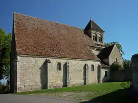 The Church of Our Lady of Puy-Ferrand, in Le Châtelet | |
 Coat of arms | |
Location of Le Châtelet 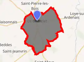
| |
 Le Châtelet  Le Châtelet | |
| Coordinates: 46°38′33″N 2°17′02″E | |
| Country | France |
| Region | Centre-Val de Loire |
| Department | Cher |
| Arrondissement | Saint-Amand-Montrond |
| Canton | Châteaumeillant |
| Government | |
| • Mayor (2008–2014) | Bernard Jamet |
| Area 1 | 32.8 km2 (12.7 sq mi) |
| Population (2017-01-01)[1] | 994 |
| • Density | 30/km2 (78/sq mi) |
| Time zone | UTC+01:00 (CET) |
| • Summer (DST) | UTC+02:00 (CEST) |
| INSEE/Postal code | 18059 /18170 |
| Elevation | 186–276 m (610–906 ft) (avg. 195 m or 640 ft) |
| 1 French Land Register data, which excludes lakes, ponds, glaciers > 1 km2 (0.386 sq mi or 247 acres) and river estuaries. | |
Geography
A farming area comprising a small town and a few hamlets situated by the banks of the small river Portefeuille, some 29 miles (47 km) south of Bourges, at the junction of the D 951, D 3 and the D 65 roads.
Population
| Year | Pop. | ±% |
|---|---|---|
| 1962 | 1,219 | — |
| 1968 | 1,226 | +0.6% |
| 1975 | 1,265 | +3.2% |
| 1982 | 1,151 | −9.0% |
| 1990 | 278 | −75.8% |
| 1999 | 1,104 | +297.1% |
| 2008 | 1,140 | +3.3% |
Sights
- The abbey church of Notre-Dame, dating from the twelfth century.
- The seventeenth century manorhouse de La Charnaye.
- Trace remains of a 12th-century castle.
- A pottery museum at the hamlet of Archers.
See also
References
- "Populations légales 2017". INSEE. Retrieved 6 January 2020.
External links
| Wikimedia Commons has media related to Le Châtelet. |
- Le Châtelet - Website of the village (in French)
| Authority control |
|
|---|
This article is issued from Wikipedia. The text is licensed under Creative Commons - Attribution - Sharealike. Additional terms may apply for the media files.