Châteauneuf-sur-Cher
Châteauneuf-sur-Cher is a commune in the Cher department in the Centre-Val de Loire region of France.
Châteauneuf-sur-Cher | |
|---|---|
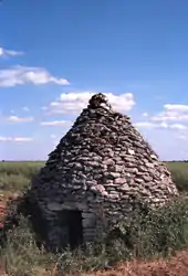 A dry stone hut located at Châteauneuf-sur-Cher | |
.svg.png.webp) Coat of arms | |
Location of Châteauneuf-sur-Cher 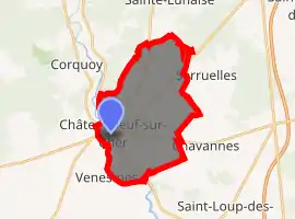
| |
 Châteauneuf-sur-Cher  Châteauneuf-sur-Cher | |
| Coordinates: 46°51′30″N 2°19′02″E | |
| Country | France |
| Region | Centre-Val de Loire |
| Department | Cher |
| Arrondissement | Saint-Amand-Montrond |
| Canton | Trouy |
| Intercommunality | CC Arnon Boischaut Cher |
| Government | |
| • Mayor (2008–2014) | William Pelletier |
| Area 1 | 21.97 km2 (8.48 sq mi) |
| Population (2017-01-01)[1] | 1,454 |
| • Density | 66/km2 (170/sq mi) |
| Time zone | UTC+01:00 (CET) |
| • Summer (DST) | UTC+02:00 (CEST) |
| INSEE/Postal code | 18058 /18190 |
| Elevation | 132–174 m (433–571 ft) (avg. 149 m or 489 ft) |
| 1 French Land Register data, which excludes lakes, ponds, glaciers > 1 km2 (0.386 sq mi or 247 acres) and river estuaries. | |
Geography
An area of farming and forestry comprising a large village and several hamlets situated in the valley of the river Cher, some 16 miles (26 km) south of Bourges at the junction of the D940 with the D73, D35 and the D14 roads.
Population
| Year | Pop. | ±% |
|---|---|---|
| 1962 | 1,701 | — |
| 1968 | 1,783 | +4.8% |
| 1975 | 1,722 | −3.4% |
| 1982 | 1,657 | −3.8% |
| 1990 | 1,645 | −0.7% |
| 1999 | 1,614 | −1.9% |
| 2008 | 1,537 | −4.8% |
Sights
- The nineteenth-century church of Notre-Dame.
- A thirteenth-century castle.
- The twelfth-century church at the hamlet of Marigny.
- The winegrowers’ stone cabin at Marigny.
Personalities
- Ernest-Francois Mallard (1833–1894), mineralogist was born here.
See also
References
- "Populations légales 2017". INSEE. Retrieved 6 January 2020.
External links
| Wikimedia Commons has media related to Châteauneuf-sur-Cher. |
| Authority control |
|
|---|
This article is issued from Wikipedia. The text is licensed under Creative Commons - Attribution - Sharealike. Additional terms may apply for the media files.