Saint-Ambroix, Cher
Saint-Ambroix is a commune in the Cher department in the Centre-Val de Loire region of France.
Saint-Ambroix | |
|---|---|
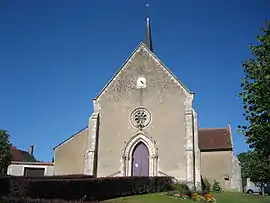 The church in Saint-Ambroix | |
.svg.png.webp) Coat of arms | |
Location of Saint-Ambroix 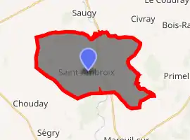
| |
 Saint-Ambroix  Saint-Ambroix | |
| Coordinates: 46°55′57″N 2°07′16″E | |
| Country | France |
| Region | Centre-Val de Loire |
| Department | Cher |
| Arrondissement | Bourges |
| Canton | Chârost |
| Intercommunality | Pays d'Issoudun |
| Government | |
| • Mayor (2008–2014) | Gérard Deve |
| Area 1 | 31.22 km2 (12.05 sq mi) |
| Population (2017-01-01)[1] | 364 |
| • Density | 12/km2 (30/sq mi) |
| Time zone | UTC+01:00 (CET) |
| • Summer (DST) | UTC+02:00 (CEST) |
| INSEE/Postal code | 18198 /18290 |
| Elevation | 125–166 m (410–545 ft) (avg. 155 m or 509 ft) |
| 1 French Land Register data, which excludes lakes, ponds, glaciers > 1 km2 (0.386 sq mi or 247 acres) and river estuaries. | |
Geography
A farming area comprising the village and two hamlets situated by the banks of the river Arnon, some 17 miles (27 km) southwest of Bourges, at the junction of the D18, D84 and the D99e roads. The commune borders the department of Indre.
Population
| Year | Pop. | ±% |
|---|---|---|
| 1962 | 468 | — |
| 1968 | 496 | +6.0% |
| 1975 | 409 | −17.5% |
| 1982 | 406 | −0.7% |
| 1990 | 386 | −4.9% |
| 1999 | 374 | −3.1% |
| 2008 | 395 | +5.6% |
Sights
- The church, dating from the twelfth century.
- A fifteenth-century manorhouse.
- Considerable Roman remains: a graveyard and artefacts.
- The remains of the priory of Semur.
See also
References
- "Populations légales 2017". INSEE. Retrieved 6 January 2020.
| Wikimedia Commons has media related to Saint-Ambroix (Cher). |
| Authority control |
|
|---|
This article is issued from Wikipedia. The text is licensed under Creative Commons - Attribution - Sharealike. Additional terms may apply for the media files.