Maisonnais
Maisonnais is a commune in the Cher department in the Centre-Val de Loire region of France.
Maisonnais | |
|---|---|
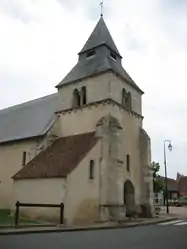 The church of Saint-Pierre and Saint-Paul, in Maisonnais | |
Location of Maisonnais 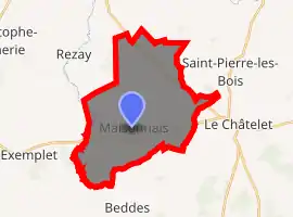
| |
 Maisonnais  Maisonnais | |
| Coordinates: 46°38′27″N 2°12′59″E | |
| Country | France |
| Region | Centre-Val de Loire |
| Department | Cher |
| Arrondissement | Saint-Amand-Montrond |
| Canton | Châteaumeillant |
| Government | |
| • Mayor (2008–2014) | Jean-Paul DuPlessis |
| Area 1 | 26.95 km2 (10.41 sq mi) |
| Population (2017-01-01)[1] | 239 |
| • Density | 8.9/km2 (23/sq mi) |
| Time zone | UTC+01:00 (CET) |
| • Summer (DST) | UTC+02:00 (CEST) |
| INSEE/Postal code | 18135 /18170 |
| Elevation | 182–247 m (597–810 ft) (avg. 240 m or 790 ft) |
| 1 French Land Register data, which excludes lakes, ponds, glaciers > 1 km2 (0.386 sq mi or 247 acres) and river estuaries. | |
Geography
A farming area comprising the village and several hamlets, situated by the banks of the river Sinaise some 32 miles (51 km) south of Bourges, on the D65 road and at the junction of the D70 and the D951 roads. The river forms much of the commune’s southwestern border with the department of Indre.
Population
| Year | Pop. | ±% |
|---|---|---|
| 1962 | 333 | — |
| 1968 | 389 | +16.8% |
| 1975 | 326 | −16.2% |
| 1982 | 276 | −15.3% |
| 1990 | 239 | −13.4% |
| 1999 | 221 | −7.5% |
| 2008 | 213 | −3.6% |
Sights
- The remains of several buildings from the medieval priory.
- The church of Saints Peter and Paul, dating from the twelfth century.
- The ornamental gardens of the priory.
See also
References
- "Populations légales 2017". INSEE. Retrieved 6 January 2020.
External links
| Wikimedia Commons has media related to Maisonnais. |
- The priory gardens at Maisonnais (in French)
| Authority control |
|
|---|
This article is issued from Wikipedia. The text is licensed under Creative Commons - Attribution - Sharealike. Additional terms may apply for the media files.
