Aransas County, Texas
Aransas County (/əˈrænzəs/ ə-RAN-zəss)[1] is a county located in the U.S. state of Texas. As of the 2010 census, the population was 23,158.[2] Its county seat is Rockport.[3] The county was formed in 1871 from Refugio County and organized the following year.[4] It was named for the Rio Nuestra Senora de Aranzazu, a Spanish outpost in early Texas.
Aransas County | |
|---|---|
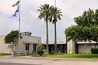 The Aransas County Courthouse | |
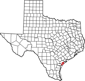 Location within the U.S. state of Texas | |
 Texas's location within the U.S. | |
| Coordinates: 28°06′N 96°59′W | |
| Country | |
| State | |
| Founded | 1872 |
| Named for | Aransas Bay |
| Seat | Rockport |
| Largest city | Rockport |
| Area | |
| • Total | 528 sq mi (1,370 km2) |
| • Land | 252 sq mi (650 km2) |
| • Water | 276 sq mi (710 km2) 52%% |
| Population (2010) | |
| • Total | 23,158 |
| • Density | 92/sq mi (36/km2) |
| Time zone | UTC−6 (Central) |
| • Summer (DST) | UTC−5 (CDT) |
| Congressional district | 27th |
| Website | www |
Aransas County is part of the Corpus Christi Metropolitan Statistical Area.
History
Aransas County was formed in 1871 from portions of Refugio County. It was named after Rio Nuestra Senora de Aranzazu, a Spanish outpost in early Texas.
The first European to see this land was probably Alonso Álvarez de Pineda, who sailed along the coast of Texas in the summer of 1519 and who also discovered the Aransas Bay.
Hurricane Harvey caused tremendous damage to the county in August 2017.
Geography
According to the U.S. Census Bureau, the county has a total area of 528 square miles (1,370 km2), of which 252 square miles (650 km2) is land and 276 square miles (710 km2) (52%) is water.[5]
Adjacent counties
- Calhoun County (northeast)
- Gulf of Mexico (east)
- Nueces County (southeast)
- San Patricio County (southwest)
- Refugio County (northwest)
National protected area
Demographics
| Historical population | |||
|---|---|---|---|
| Census | Pop. | %± | |
| 1880 | 966 | — | |
| 1890 | 1,824 | 88.8% | |
| 1900 | 1,716 | −5.9% | |
| 1910 | 2,106 | 22.7% | |
| 1920 | 2,064 | −2.0% | |
| 1930 | 2,219 | 7.5% | |
| 1940 | 3,469 | 56.3% | |
| 1950 | 4,252 | 22.6% | |
| 1960 | 7,006 | 64.8% | |
| 1970 | 8,902 | 27.1% | |
| 1980 | 14,260 | 60.2% | |
| 1990 | 17,892 | 25.5% | |
| 2000 | 22,497 | 25.7% | |
| 2010 | 23,158 | 2.9% | |
| 2019 (est.) | 23,510 | [6] | 1.5% |
| U.S. Decennial Census[7] 1850–2010[8] 2010–2014[2] | |||
As of the census[9] of 2000, there were 22,497 people, 9,132 households, and 6,401 families residing in the county. The population density was 89 people per square mile (34/km2). There were 12,848 housing units at an average density of 51 per square mile (20/km2). The racial makeup of the county was 87.44% White, 1.43% Black or African American, 0.58% Native American, 2.77% Asian, 0.05% Pacific Islander, 5.33% from other races, and 2.39% from two or more races. 20.32% of the population were Hispanic or Latino of any race.
There were 9,132 households, out of which 27.00% had children under the age of 18 living with them, 57.00% were married couples living together, 9.40% had a female householder with no husband present, and 29.90% were non-families. 25.30% of all households were made up of individuals, and 11.60% had someone living alone who was 65 years of age or older. The average household size was 2.43 and the average family size was 2.90. As of the 2010 census, there were about 5.9 same-sex couples per 1,000 households in the county.[10]
In the county, the population was spread out, with 23.80% under the age of 18, 6.20% from 18 to 24, 23.20% from 25 to 44, 27.10% from 45 to 64, and 19.70% who were 65 years of age or older. The median age was 43 years. For every 100 females there were 98.90 males. For every 100 females age 18 and over, there were 95.50 males.
The median income for a household in the county was $30,702, and the median income for a family was $34,915. Males had a median income of $31,597 versus $20,289 for females. The per capita income for the county was $18,560. About 15.50% of families and 19.90% of the population were below the poverty line, including 31.00% of those under age 18 and 10.20% of those age 65 or over.
Education
Most county residents, including the cities of Rockport and Fulton, are served by the Aransas County Independent School District.
Some residents (including the city of Aransas Pass, which is actually outside of the county) are served by the Aransas Pass Independent School District.
Transportation
Major highways
 State Highway 35
 State Highway 188
Airport
Aransas County Airport is located in Fulton, north of Rockport.
Communities
Cities
- Aransas Pass (partly in San Patricio and Nueces counties)
- Corpus Christi (mostly in Nueces County with small parts in Kleberg and San Patricio counties)
- Rockport (county seat)
Towns
Census-designated places
Ghost towns
Politics
| Year | Republican | Democratic | Third parties |
|---|---|---|---|
| 2020 | 75.2% 9,239 | 23.7% 2,916 | 1.1% 135 |
| 2016 | 73.6% 7,740 | 23.5% 2,465 | 2.9% 307 |
| 2012 | 70.8% 6,830 | 28.0% 2,704 | 1.2% 114 |
| 2008 | 68.5% 6,693 | 30.7% 3,006 | 0.8% 79 |
| 2004 | 70.9% 6,569 | 28.5% 2,640 | 0.6% 59 |
| 2000 | 65.4% 5,390 | 32.0% 2,637 | 2.7% 220 |
| 1996 | 50.7% 3,769 | 39.8% 2,964 | 9.5% 707 |
| 1992 | 41.7% 2,826 | 33.2% 2,246 | 25.1% 1,698 |
| 1988 | 62.3% 3,858 | 37.2% 2,305 | 0.5% 33 |
| 1984 | 71.7% 4,352 | 28.0% 1,696 | 0.3% 19 |
| 1980 | 60.8% 3,081 | 35.5% 1,800 | 3.7% 187 |
| 1976 | 47.5% 1,985 | 51.1% 2,136 | 1.4% 60 |
| 1972 | 70.5% 2,037 | 29.2% 844 | 0.3% 9 |
| 1968 | 39.6% 1,076 | 45.0% 1,222 | 15.4% 417 |
| 1964 | 28.7% 602 | 71.0% 1,492 | 0.3% 7 |
| 1960 | 45.3% 792 | 54.2% 948 | 0.5% 8 |
| 1956 | 63.7% 757 | 35.7% 425 | 0.6% 7 |
| 1952 | 61.7% 818 | 38.0% 503 | 0.3% 4 |
| 1948 | 34.3% 235 | 61.0% 418 | 4.7% 32 |
| 1944 | 24.2% 150 | 73.4% 456 | 2.4% 15 |
| 1940 | 20.8% 141 | 79.2% 536 | |
| 1936 | 21.7% 60 | 74.4% 206 | 4.0% 11 |
| 1932 | 12.7% 39 | 87.0% 268 | 0.3% 1 |
| 1928 | 51.4% 161 | 48.6% 152 | |
| 1924 | 27.0% 75 | 70.1% 195 | 2.9% 8 |
| 1920 | 25.1% 49 | 74.9% 146 | |
| 1916 | 11.4% 24 | 84.8% 179 | 3.8% 8 |
| 1912 | 3.1% 7 | 83.1% 187 | 13.8% 31 |
See also
References
- "How to Pronounce: A Cities". TexasTripper.com Texas Travel Guide. 2014-09-21. Retrieved 2018-07-19.
- "State & County QuickFacts". United States Census Bureau. Archived from the original on July 6, 2011. Retrieved December 8, 2013.
- "Find a County". National Association of Counties. Archived from the original on 2011-05-31. Retrieved 2011-06-07.
- "Texas: Individual County Chronologies". Texas Atlas of Historical County Boundaries. The Newberry Library. 2008. Retrieved May 20, 2015.
- "2010 Census Gazetteer Files". United States Census Bureau. August 22, 2012. Retrieved April 18, 2015.
- "Population and Housing Unit Estimates". United States Census Bureau. May 24, 2020. Retrieved May 27, 2020.
- "U.S. Decennial Census". United States Census Bureau. Retrieved April 18, 2015.
- "Texas Almanac: Population History of Counties from 1850–2010" (PDF). Texas Almanac. Retrieved April 18, 2015.
- "U.S. Census website". United States Census Bureau. Retrieved 2011-05-14.
- Leonhardt, David; Quealy, Kevin (June 26, 2015), "Where Same-Sex Couples Live", The New York Times, retrieved July 6, 2015
- Leip, David. "Dave Leip's Atlas of U.S. Presidential Elections". uselectionatlas.org. Retrieved 2018-07-19.
External links
- Aransas County government
- Aransas County from the Handbook of Texas Online
- Aransas County from the Texas Almanac
- Aransas County from the TXGenWeb Project
- Historic Photographs of Aransas County
Places adjacent to Aransas County, Texas | ||||||||||
|---|---|---|---|---|---|---|---|---|---|---|
| ||||||||||
Municipalities and communities of Aransas County, Texas, United States | ||
|---|---|---|
| Cities | Aransas County map | |
| Town | ||
| CDPs | ||
| Ghost town | ||
| Footnotes | ‡This populated place also has portions in an adjacent county or counties | |
| ||

| Authority control |
|---|