Freestone County, Texas
Freestone County is a county located in the east central part of the U.S. state of Texas. As of the 2010 census, the population was 19,816.[1] Its county seat is Fairfield.[2] The county was created in 1850 and organized the next year.[3]
Freestone County | |
|---|---|
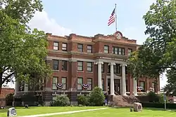 The Freestone County Courthouse in Fairfield | |
 Location within the U.S. state of Texas | |
 Texas's location within the U.S. | |
| Coordinates: 31°42′N 96°09′W | |
| Country | |
| State | |
| Founded | 1851 |
| Seat | Fairfield |
| Largest city | Teague |
| Area | |
| • Total | 892 sq mi (2,310 km2) |
| • Land | 878 sq mi (2,270 km2) |
| • Water | 14 sq mi (40 km2) 1.6%% |
| Population (2010) | |
| • Total | 19,816 |
| • Density | 23/sq mi (9/km2) |
| Time zone | UTC−6 (Central) |
| • Summer (DST) | UTC−5 (CDT) |
| Congressional district | 17th |
| Website | www |
History
Native Americans
Archeological evidence of the farming Kichai[4] band of the Caddoan Mississippian culture dates to 200 BCE in the area.[5]
The Hernando de Soto expedition of 1541 resulted in violent encounters with the Caddo Native Americans who occupied the area. Spanish and French missionaries carried smallpox, measles, malaria, and influenza as endemic diseases; the Caddo suffered epidemics as they had no acquired immunity to these new diseases.[6] Eventually, the Caddo were forced to reservations.
The Tawakoni[7] branch of Wichita Indians originated as a tribe north of Texas, but migrated south into east Texas. From 1843 onward, the Tawakoni were part of treaties made by both the Republic of Texas and the United States. The name of the Tawakoni was also sometimes spelled as Tehuacana.
County established
In 1826, empresario David G. Burnet received a grant from the Coahuila y Tejas legislature to settle 300 families.[8] By contracting how many families each grantee could settle, the government sought to have some control over colonization.
The threat of Indian hostilities kept most from homesteading in Freestone County until the Treaty of Bird's Fort.[9] Within three years of the treaty, colonization, primarily from Southern states, had been so successful that the counties surrounding Freestone had already been organized. In 1850 the Texas legislature formed Freestone County from Limestone County. Freestone is a descriptive name referring to the quality of the soil.[10] The county was organized in 1851. Fairfield was designated as the county seat. Of the county's total 1860 population of 6,881,[11] more than half (3,613) were slaves.
Freestone County voted 585–3 in favor of secession from the Union. After the Civil War, while the loss of slave labor may have hurt the planters in the local county economy, by the end of Reconstruction, the number of farms doubled. There were more smaller farms than before the war. Continuing economic and social tensions after Reconstruction resulted in whites lynching blacks to keep them in place as second-class citizens. Freestone County had nine such lynchings from 1877 into the early 20th century, most around the turn of the century. This was the fifth-highest total in the state, tied with that of Grimes County, Texas.[12]
The Houston and Texas Central Railway was constructed to skirt the county to the west and south in 1870, giving the local economy a boost.[13] and the International – Great Northern Railroad[14] The Trinity and Brazos Valley Railway,[15] laid track across the county in 1906, helping the growing economy.
The Prohibition Eighteenth Amendment to the United States Constitution took effect in 1920, banning the sale, manufacturing and transportation of alcoholic beverages for public consumption. In the period until its repeal by the Twenty-first Amendment to the United States Constitution in 1933,[16] some enterprising individuals in Freestone followed a national trend and began bootlegging for profit. This illegal activity put food on the table for some people during a period when the local economy was in a downward slide.
In 1969, the Texas Utilities Generating Company located a new power plant near Fairfield called Big Brown Power Plant. A dam was built to create Fairfield Lake to provide stored water for a cooling system for the plant.[17] Fairfield Lake State Park was established around the lake and opened to the public in 1976.[18] Big Brown was shut down in February 2018.[19]
Geography
According to the U.S. Census Bureau, the county has a total area of 892 square miles (2,310 km2), of which 878 square miles (2,270 km2) is land and 14 square miles (36 km2) (1.6%) is water.[20]
Major highways
.svg.png.webp) Interstate 45
Interstate 45 U.S. Highway 79
 U.S. Highway 84
 U.S. Highway 287
 State Highway 14
 State Highway 75
 State Highway 164
 State Highway 179
Adjacent counties
- Henderson County (north)
- Anderson County (northeast)
- Leon County (southeast)
- Limestone County (southwest)
- Navarro County (northwest)
Demographics
| Historical population | |||
|---|---|---|---|
| Census | Pop. | %± | |
| 1860 | 6,881 | — | |
| 1870 | 8,139 | 18.3% | |
| 1880 | 14,921 | 83.3% | |
| 1890 | 15,987 | 7.1% | |
| 1900 | 18,910 | 18.3% | |
| 1910 | 20,557 | 8.7% | |
| 1920 | 23,264 | 13.2% | |
| 1930 | 22,589 | −2.9% | |
| 1940 | 21,138 | −6.4% | |
| 1950 | 15,696 | −25.7% | |
| 1960 | 12,525 | −20.2% | |
| 1970 | 11,116 | −11.2% | |
| 1980 | 14,830 | 33.4% | |
| 1990 | 15,818 | 6.7% | |
| 2000 | 17,867 | 13.0% | |
| 2010 | 19,816 | 10.9% | |
| 2019 (est.) | 19,717 | [21] | −0.5% |
| U.S. Decennial Census[22] 1850–2010[23] 2010–2014[1] | |||
As of the census[24] of 2010, there were 19,816 people, 6,588 households, and 4,664 families residing in the county. The population density was 20 people per square mile (8/km2). There were 8,138 housing units at an average density of 9 per square mile (4/km2).
The racial makeup of the county was 73.1% White, 16.1% Black or African American, 0.7% Native American, 0.3% Asian, 0.0% Pacific Islander, 8.1% from other races, and 1.6% from two or more races. 13.6% of the population were Hispanic or Latino of any race.
There were 7,259 households, out of which 28% had children under the age of 18 living with them, 54.5% were married couples living together, 10.5% had a female householder with no husband present, and 30.6% were non-families. 27% of all households were made up of individuals, and 12.4% had someone living alone who was 65 years of age or older. The average household size was 2.51 and the average family size was 3.05.
In the county, the population was spread out, with 25.5% ages 19 and under, 4.8% from 20 to 24, 25.1% from 25 to 44, 28.1% from 45 to 64, and 16.6% who were 65 years of age or older. The median age was 40.9 years. For every 100 females there were 111.2 males. For every 100 females age 18 and over, there were 110.80 males.
The median income for a household in the county was $44,560, and the median income for a family was $59,696. Males had a median income of $30,633 versus $19,214 for females. The per capita income for the county was $16,338. About 9.80% of families and 14.20% of the population were below the poverty line, including 16.80% of those under age 18 and 14.30% of those age 65 or over.
Media
Freestone County is currently listed as part of the Dallas-Fort Worth DMA. Local media outlets include: KDFW-TV, KXAS-TV, WFAA-TV, KTVT-TV, KERA-TV, KTXA-TV, KDFI-TV, KDAF-TV, and KFWD-TV. Although located in eastern Central Texas geographically closer to the Waco metropolitan area. Meaning all of the Waco/Temple/Killeen market stations also provide coverage for Freestone County. They include: KCEN-TV, KWTX-TV, KXXV-TV, KDYW, and KWKT-TV.
The Freestone County Times and The Fairfield Recorder newspaper serves Fairfield. The Teague Chronicle is the hometown newspaper of Teague (Freestone County), Texas and has served Teague and Freestone County for the past 107 years.
Communities
Towns
- Kirvin
- Oakwood (mostly in Leon County)
- Streetman (small part in Navarro County)
- Wortham
Ghost town
Historic communities
Historic communities in Freestone County have included Baty, Beene, Blunt, Bonner,[25] Bowling, Brewster, Butler, Cobb, Cotton Gin, Driver, Flowerdale, Freestone, Goetz, Harp, Israel, Ivory, Keechil, Lakeport, Lanely, Long Bottom, Luna, Mills, Milton, Morehead, Mount Zion, Pinoak, Pyburn, Shanks, St. Elmo, Starling, Steward's Mill, Stonewall, Troy, Turlington, Valota, Wakefield, West Point, Winkler, Yedell, Yerby, and Young.[26]
Notable residents
- Leonard Davis (born 1978), NFL offensive lineman for the Dallas Cowboys, grew up in Wortham
- Blind Lemon Jefferson (1893–1929), blues musician, born near Wortham
- Washington Phillips (1880–1954), gospel blues musician, born in the county
- George Watkins (1900–70), Major League Baseball player who owns the record for highest batting average as a rookie
Politics
| Year | Republican | Democratic | Third parties |
|---|---|---|---|
| 2020 | 80.3% 6,991 | 18.8% 1,635 | 1.0% 85 |
| 2016 | 78.4% 6,026 | 19.1% 1,471 | 2.4% 187 |
| 2012 | 74.6% 5,646 | 24.4% 1,850 | 1.0% 74 |
| 2008 | 71.4% 5,205 | 27.9% 2,034 | 0.7% 49 |
| 2004 | 70.6% 5,057 | 28.9% 2,070 | 0.5% 34 |
| 2000 | 64.0% 4,247 | 34.9% 2,316 | 1.2% 78 |
| 1996 | 47.4% 2,888 | 43.1% 2,630 | 9.5% 579 |
| 1992 | 36.4% 2,316 | 38.4% 2,445 | 25.2% 1,604 |
| 1988 | 51.9% 3,159 | 47.9% 2,916 | 0.3% 17 |
| 1984 | 59.2% 3,624 | 40.7% 2,489 | 0.2% 9 |
| 1980 | 46.9% 2,468 | 52.0% 2,739 | 1.1% 58 |
| 1976 | 38.4% 1,674 | 61.4% 2,679 | 0.2% 8 |
| 1972 | 65.6% 2,459 | 34.2% 1,283 | 0.2% 6 |
| 1968 | 23.4% 958 | 50.5% 2,066 | 26.1% 1,069 |
| 1964 | 27.6% 1,074 | 72.4% 2,816 | 0.1% 2 |
| 1960 | 44.6% 1,629 | 54.7% 1,997 | 0.7% 24 |
| 1956 | 47.1% 1,627 | 52.5% 1,813 | 0.4% 15 |
| 1952 | 37.0% 1,707 | 62.9% 2,902 | 0.0% 2 |
| 1948 | 14.2% 460 | 70.1% 2,265 | 15.6% 505 |
| 1944 | 9.2% 277 | 80.3% 2,427 | 10.5% 318 |
| 1940 | 12.0% 481 | 87.9% 3,514 | 0.1% 5 |
| 1936 | 6.5% 134 | 93.2% 1,929 | 0.3% 6 |
| 1932 | 6.4% 170 | 93.4% 2,481 | 0.2% 5 |
| 1928 | 47.1% 1,178 | 52.7% 1,318 | 0.1% 3 |
| 1924 | 19.2% 608 | 78.3% 2,484 | 2.5% 80 |
| 1920 | 13.7% 378 | 53.2% 1,463 | 33.1% 911 |
| 1916 | 27.6% 637 | 68.2% 1,575 | 4.3% 99 |
| 1912 | 26.2% 475 | 72.1% 1,305 | 1.7% 30 |
See also
References
- "State & County QuickFacts". United States Census Bureau. Archived from the original on October 18, 2011. Retrieved December 16, 2013.
- "Find a County". National Association of Counties. Archived from the original on May 31, 2011. Retrieved June 7, 2011.
- "Texas: Individual County Chronologies". Texas Atlas of Historical County Boundaries. The Newberry Library. 2008. Retrieved May 23, 2015.
- "Kichai Indian History". Access Genealogy. Retrieved May 2, 2010.
- "Caddo Timeline". Texas Beyond History. Retrieved May 2, 2010.
- "Caddo (Kadahadacho)". Oklahoma Historical Society. Archived from the original on July 19, 2010. Retrieved May 2, 2010. Oklahoma Historical Society
- Krieger, Margery H: Tawakoni Indians from the Handbook of Texas Online. Retrieved 2 May 2010. Texas State Historical Association
- "Empresario Contracts in the Colonization of Texas 1825–1834". Texas A & M University. Archived from the original on June 15, 2010. Retrieved May 2, 2010. Wallace L. McKeehan,
- "Treaty Negotiations 1825–1834". Texas State Library and Archives Commission. Retrieved May 2, 2010.
- Gannett, Henry (1905). The Origin of Certain Place Names in the United States. Govt. Print. Off. p. 132.
- Leffler, John: Freestone County from the Handbook of Texas Online. Retrieved May 2, 2010. Texas State Historical Association
- "Lynching in America, Third Edition: Supplement by County" (PDF). eji.org. Mobile, AL: Equal Justice Initiative. 2017. p. 9. Archived from the original (PDF) on October 23, 2017. Retrieved August 27, 2019.
- Werner, George C: Houston Texas and Central Railway from the Handbook of Texas Online. Retrieved May 2, 2010. Texas State Historical Association
- Werner, George C: International-Great Northern Railroad from the Handbook of Texas Online. Retrieved May 2, 2010. Texas State Historical Association
- "Trinity and Brazos Valley Railway". Don's Depot. Retrieved May 2, 2010.
- "Freestone Bootlegging". Fairfield Chamber of Commerce. Retrieved May 2, 2010.
- "Fairfield Lake (Trinity River Basin)". Texas Water Development Board. Retrieved February 14, 2018.
- "Fairfield Lake State Park History". Texas Parks & Wildlife Department. Retrieved February 14, 2018.
- Zhou, Jeff (November 6, 2017). "ERCOT OKs Vistra's plan to retire 2,400 MW coal capacity in Texas". Platts. Retrieved February 14, 2018.
- "2010 Census Gazetteer Files". United States Census Bureau. August 22, 2012. Retrieved April 26, 2015.
- "Population and Housing Unit Estimates". United States Census Bureau. May 24, 2020. Retrieved May 27, 2020.
- "U.S. Decennial Census". United States Census Bureau. Retrieved April 26, 2015.
- "Texas Almanac: Population History of Counties from 1850–2010" (PDF). Texas Almanac. Retrieved April 26, 2015.
- "U.S. Census website". United States Census Bureau. Retrieved May 14, 2011.
- A Memorial and Biographical History of Navarro, Henderson, Anderson, Limestone, Freestone and Leon Counties, Texas. Chicago: Lewis Publishing Company. 1893. p. 431. Retrieved September 28, 2014.
- "Postmasters and Post Offices of Freestone County, Texas 1850 – 1930". RootsWeb.com. Ancestry.com. Retrieved August 27, 2019.
- Leip, David. "Dave Leip's Atlas of U.S. Presidential Elections". uselectionatlas.org. Retrieved July 23, 2018.
External links
- Official website

- Freestone County government's website
- Freestone County from the Handbook of Texas Online
- See a map, Freestone County / sponsored by Freestone County Historical Survey Committee. hosted by the Portal to Texas History.
- Freestone County Times homepage
Places adjacent to Freestone County, Texas | ||||||||||
|---|---|---|---|---|---|---|---|---|---|---|
| ||||||||||
Municipalities and communities of Freestone County, Texas, United States | ||
|---|---|---|
| Cities | Freestone County map | |
| Towns | ||
| Unincorporated communities | ||
| Ghost town | ||
| Footnotes | ‡This populated place also has portions in an adjacent county or counties | |
| ||

| Authority control |
|---|