Brooks County, Texas
Brooks County is a county located in the U.S. state of Texas. As of the 2010 census, its population was 7,223.[1] Its county seat is Falfurrias.[2] The county is named for James Abijah Brooks, a Texas Ranger and legislator.
Brooks County | |
|---|---|
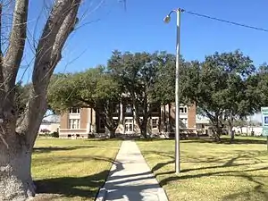 The Brooks County Courthouse in Falfurrias | |
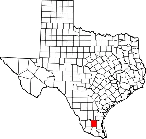 Location within the U.S. state of Texas | |
 Texas's location within the U.S. | |
| Coordinates: 27°02′N 98°13′W | |
| Country | |
| State | |
| Founded | 1911 |
| Named for | James Brooks |
| Seat | Falfurrias |
| Largest city | Falfurrias |
| Area | |
| • Total | 944 sq mi (2,440 km2) |
| • Land | 943 sq mi (2,440 km2) |
| • Water | 0.3 sq mi (0.8 km2) 0.03%% |
| Population (2010) | |
| • Total | 7,223 |
| • Density | 7.7/sq mi (3.0/km2) |
| Time zone | UTC−6 (Central) |
| • Summer (DST) | UTC−5 (CDT) |
| Congressional district | 15th |
| Website | www |
The county faces a range of challenges due to immigration issues. Though it lies about 80 miles north of the border, it is a main route for migrants crossing from Mexico. The open, dry terrain and hot summer temperatures cause many immigrants to die, leading some to dub the area a "Death Valley" for migrants.[3][4][5]
Geography
According to the U.S. Census Bureau, the county has a total area of 944 sq mi (2,440 km2), of which 943 sq mi (2,440 km2) are land and 0.3 sq mi (0.78 km2) (0.03%) is covered by water.[6]
Major highways
 U.S. Highway 281
.svg.png.webp) Interstate 69C is currently under construction and will follow the current route of U.S. 281 in most places.
Interstate 69C is currently under construction and will follow the current route of U.S. 281 in most places.
 State Highway 285
 Farm to Market Road 755
Adjacent counties
- Jim Wells County (north)
- Kleberg County (northeast)
- Kenedy County (east)
- Hidalgo County (south)
- Starr County (southwest)
- Jim Hogg County (west)
- Duval County (northwest)
Demographics
| Historical population | |||
|---|---|---|---|
| Census | Pop. | %± | |
| 1920 | 4,560 | — | |
| 1930 | 5,901 | 29.4% | |
| 1940 | 6,362 | 7.8% | |
| 1950 | 9,195 | 44.5% | |
| 1960 | 8,609 | −6.4% | |
| 1970 | 8,005 | −7.0% | |
| 1980 | 8,428 | 5.3% | |
| 1990 | 8,204 | −2.7% | |
| 2000 | 7,976 | −2.8% | |
| 2010 | 7,223 | −9.4% | |
| 2019 (est.) | 7,093 | [7] | −1.8% |
| U.S. Decennial Census[8] 1850–2010[9] 2010–2014[1] | |||
As of the 2010 United States Census, 7,223 people were living in the county; 89.6% were White, 0.5% African American, 0.3% Native American, 0.3% Asian, 7.9% of some other race, and 1.4% of two or more races. About 91.2% were Hispanic or Latino (of any race).
As of the census[10] of 2000, 7,976 people, 2,711 households, and 2,079 families were residing in the county. The population density was 8 people/sq mi (3/km2). The 3,203 housing units averaged 3 per sq mi (1/km2). The racial makeup of the county was 75.84% White, 0.19% African American, 0.46% Native American, 0.09% Asian, 0.08% Pacific Islander, 21.58% from other races, and 1.77% from two or more races. About 91.57% of the population was Hispanic or Latino of any race.
Of the 2,711 households, 38.90% had children under the age of 18 living with them, 52.20% were married couples living together, 19.10% had a female householder with no husband present, and 23.30% were not families. About 21.40% of all households were made up of individuals, and 11.30% had someone living alone who was 65 years of age or older. The average household size was 2.92, and the average family size was 3.38.
In the county, the age distribution was 31.60% under the age of 18, 8.90% from 18 to 24, 23.40% from 25 to 44, 21.70% from 45 to 64, and 14.40% who were 65 years of age or older. The median age was 34 years. For every 100 females there were 94.20 males. For every 100 females age 18 and over, there were 89.90 males.
The median income for a household in the county was $18,622, and for a family was $22,473. Males had a median income of $23,051 versus $16,103 for females. The per capita income for the county was $10,234. About 36.90% of families and 40.20% of the population were below the poverty line, including 51.70% of those under age 18 and 30.40% of those age 65 or over.
Politics
While Texas has become a stronghold of the Republican Party in the 21st century, Brooks County rests in the oldest extant Democratic stronghold in the state. It has never voted for a Republican presidential candidate since its creation in 1911.
Until 2020, no Republican had received more than 35% of the vote in the county since Richard Nixon in his 1972 landslide, and no Democrat since George McGovern that same year had received less than 65%. McGovern is one of only three Democrats, the others being Adlai Stevenson in 1956, and Joe Biden in 2020, to have received less than 60% of the vote in Brooks County since it first participated in presidential elections in 1912. In 2020, the county had a swing toward the Republican party in the national election. Despite the county still voting Democratic, it only gave 59% of the vote to Biden; his performance was the worst by a Democrat in Brooks County since 1956. Donald Trump was the first Republican to carry over 40% of the county's vote since 1972.
The only instance of Brooks County having ever cast its votes for a Republican was in 2010, when Comptroller Susan Combs won it during her re-election, as no Democrat filed to run.[11]
| Year | Republican | Democratic | Third parties |
|---|---|---|---|
| 2020 | 40.2% 998 | 59.2% 1,470 | 0.6% 16 |
| 2016 | 23.6% 613 | 74.6% 1,937 | 1.8% 46 |
| 2012 | 21.1% 507 | 78.5% 1,886 | 0.4% 10 |
| 2008 | 24.1% 556 | 75.7% 1,747 | 0.3% 6 |
| 2004 | 31.6% 845 | 68.2% 1,823 | 0.2% 6 |
| 2000 | 22.9% 556 | 76.3% 1,854 | 0.9% 21 |
| 1996 | 11.8% 413 | 84.4% 2,945 | 3.7% 130 |
| 1992 | 15.5% 585 | 75.9% 2,856 | 8.6% 324 |
| 1988 | 17.4% 608 | 81.9% 2,859 | 0.6% 22 |
| 1984 | 24.8% 896 | 74.8% 2,702 | 0.4% 16 |
| 1980 | 23.4% 780 | 74.7% 2,488 | 2.0% 65 |
| 1976 | 18.7% 641 | 81.1% 2,782 | 0.2% 6 |
| 1972 | 40.2% 1,117 | 59.6% 1,657 | 0.3% 7 |
| 1968 | 20.5% 534 | 73.1% 1,904 | 6.4% 166 |
| 1964 | 14.9% 402 | 85.1% 2,299 | 0.1% 2 |
| 1960 | 22.6% 567 | 77.0% 1,934 | 0.4% 10 |
| 1956 | 41.8% 802 | 57.7% 1,108 | 0.5% 10 |
| 1952 | 33.9% 809 | 66.1% 1,577 | 0.0% 1 |
| 1948 | 16.9% 217 | 80.3% 1,029 | 2.8% 36 |
| 1944 | 22.4% 142 | 63.5% 403 | 14.2% 90 |
| 1940 | 23.0% 201 | 76.6% 670 | 0.5% 4 |
| 1936 | 24.2% 117 | 75.6% 365 | 0.2% 1 |
| 1932 | 12.3% 86 | 87.2% 608 | 0.4% 3 |
| 1928 | 32.5% 160 | 67.5% 332 | |
| 1924 | 22.0% 59 | 76.5% 205 | 1.5% 4 |
| 1920 | 22.6% 37 | 77.4% 127 | |
| 1916 | 37.7% 63 | 60.5% 101 | 1.8% 3 |
| 1912 | 2.2% 13 | 69.1% 402 | 28.7% 167 |
See also
References
- "State & County QuickFacts". United States Census Bureau. Archived from the original on October 23, 2015. Retrieved December 8, 2013.
- "Find a County". National Association of Counties. Archived from the original on 2011-05-31. Retrieved 2011-06-07.
- (9 July 2014). Texas' Brooks County Is 'Death Valley' for Migrants, NBC News
- Saslow, Eli. "Going it alone". www.washingtonpost.com. The Washington Post. Retrieved 10 August 2014.
- (10 July 2018). The Brutal Border, U.S. News & World Report
- "2010 Census Gazetteer Files". United States Census Bureau. August 22, 2012. Retrieved April 19, 2015.
- "Population and Housing Unit Estimates". United States Census Bureau. May 24, 2020. Retrieved May 27, 2020.
- "U.S. Decennial Census". United States Census Bureau. Retrieved April 19, 2015.
- "Texas Almanac: Population History of Counties from 1850–2010" (PDF). Texas Almanac. Retrieved April 19, 2015.
- "U.S. Census website". United States Census Bureau. Retrieved 2011-05-14.
- "2010 Comptroller General General Election Results". David Leip's Atlas of U.S. Presidential Elections.
- Leip, David. "Dave Leip's Atlas of U.S. Presidential Elections". uselectionatlas.org. Retrieved 2018-07-19.
External links
- Brooks County in Handbook of Texas Online.
- Brooks County Profile from the Texas Association of Counties
Places adjacent to Brooks County, Texas | ||||||||||
|---|---|---|---|---|---|---|---|---|---|---|
| ||||||||||
Municipalities and communities of Brooks County, Texas, United States | ||
|---|---|---|
| City | Brooks County map | |
| CDPs | ||
| Other unincorporated community | ||
| ||
