Foard County, Texas
Foard County is a county located in the U.S. state of Texas. As of the 2010 census, its population was 1,336.[1] Its county seat is Crowell,[2] which is also the county's only incorporated community. The county is named for Robert Levi Foard, an attorney who served as a major with the Confederate Army,[3][4] in the American Civil War.
Foard County | |
|---|---|
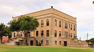 The Foard County Courthouse in Crowell, Texas | |
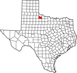 Location within the U.S. state of Texas | |
 Texas's location within the U.S. | |
| Coordinates: 33°59′N 99°47′W | |
| Country | |
| State | |
| Founded | 1891 |
| Named for | Robert Levi Foard |
| Seat | Crowell |
| Largest city | Crowell |
| Area | |
| • Total | 708 sq mi (1,830 km2) |
| • Land | 704 sq mi (1,820 km2) |
| • Water | 3.3 sq mi (9 km2) 0.5%% |
| Population (2010) | |
| • Total | 1,336 |
| • Density | 1.9/sq mi (0.7/km2) |
| Time zone | UTC−6 (Central) |
| • Summer (DST) | UTC−5 (CDT) |
| Congressional district | 13th |
Foard County was one of 46 prohibition, or entirely dry, counties in the state of Texas until voters approved a referendum to permit the legal sale of alcoholic beverages in May 2006.
Foard County is represented in the Texas House of Representatives by the Republican James Frank, a businessman from Wichita Falls.
Geography
According to the U.S. Census Bureau, the county has a total area of 708 square miles (1,830 km2), of which 704 square miles (1,820 km2) is land and 3.3 square miles (8.5 km2) (0.5%) is covered by water.[5]
Major highways
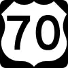 U.S. Highway 70
 State Highway 6
Adjacent counties
- Hardeman County (north)
- Wilbarger County (east)
- Baylor County (southeast)
- Knox County (south)
- King County (southwest)
- Cottle County (west)
Demographics
| Historical population | |||
|---|---|---|---|
| Census | Pop. | %± | |
| 1900 | 1,568 | — | |
| 1910 | 5,726 | 265.2% | |
| 1920 | 4,747 | −17.1% | |
| 1930 | 6,315 | 33.0% | |
| 1940 | 5,237 | −17.1% | |
| 1950 | 4,216 | −19.5% | |
| 1960 | 3,125 | −25.9% | |
| 1970 | 2,211 | −29.2% | |
| 1980 | 2,158 | −2.4% | |
| 1990 | 1,794 | −16.9% | |
| 2000 | 1,622 | −9.6% | |
| 2010 | 1,336 | −17.6% | |
| 2019 (est.) | 1,155 | [6] | −13.5% |
| U.S. Decennial Census[7] 1850–2010[8] 2010–2014[1] | |||
As of the census[9] of 2000, 1,622 people, 664 households, and 438 families resided in the county. The population density was two people per square mile (1/km2). The 850 housing units averaged one per square mile. The racial makeup of the county was 84.16% White, 3.27% Black or African American, 0.62% Native American, 0.18% Asian, 10.23% from other races, and 1.54% from two or more races. About 16.34% of the population was Hispanic or Latino of any race.
Of the 664 households, 29.10% had children under the age of 18 living with them, 54.10% were married couples living together, 9.50% had a female householder with no husband present, and 34.00% were not families; 31.80% of all households were made up of individuals, and 19.30% had someone living alone who was 65 years of age or older. The average household size was 2.38, and the average family size was 3.02. As of the 2010 census, about seven same-sex couples per 1,000 households were in the county.[10]
In the county, the population was distributed as 25.80% under the age of 18, 5.80% from 18 to 24, 22.30% from 25 to 44, 22.90% from 45 to 64, and 23.10% who were 65 years of age or older. The median age was 42 years. For every 100 females, there were 86.40 males. For every 100 females age 18 and over, there were 85.10 males.
The median income for a household in the county was $25,813, and for a family was $34,211. Males had a median income of $21,852 versus $16,450 for females. The per capita income for the county was $14,799. About 9.90% of families and 14.30% of the population were below the poverty line, including 14.50% of those under age 18 and 16.20% of those age 65 or over.
Politics
Foard County was once a stronghold for the Democratic Party at both the state and federal levels, both by Solid South standards and as the rest of North Texas and the rural parts of the state trended towards the Republican Party. The county last voted for a Democratic presidential candidate when it gave its votes to Bill Clinton in 1996.
| Year | Republican | Democratic | Third parties |
|---|---|---|---|
| 2020 | 80.8% 445 | 18.0% 99 | 1.3% 7 |
| 2016 | 74.7% 383 | 22.0% 113 | 3.3% 17 |
| 2012 | 70.3% 348 | 28.3% 140 | 1.4% 7 |
| 2008 | 60.8% 327 | 36.8% 198 | 2.4% 13 |
| 2004 | 59.1% 347 | 40.0% 235 | 0.9% 5 |
| 2000 | 51.4% 286 | 47.3% 263 | 1.3% 7 |
| 1996 | 29.0% 166 | 62.0% 355 | 9.1% 52 |
| 1992 | 26.0% 207 | 54.7% 435 | 19.4% 154 |
| 1988 | 37.3% 306 | 62.6% 513 | 0.1% 1 |
| 1984 | 51.0% 472 | 48.4% 448 | 0.5% 5 |
| 1980 | 35.7% 349 | 63.1% 617 | 1.2% 12 |
| 1976 | 25.3% 240 | 74.3% 706 | 0.4% 4 |
| 1972 | 53.9% 369 | 45.6% 312 | 0.6% 4 |
| 1968 | 22.1% 216 | 60.7% 594 | 17.2% 168 |
| 1964 | 14.9% 146 | 85.0% 833 | 0.1% 1 |
| 1960 | 27.1% 270 | 72.7% 723 | 0.2% 2 |
| 1956 | 26.1% 243 | 73.7% 687 | 0.2% 2 |
| 1952 | 33.3% 418 | 66.1% 830 | 0.6% 8 |
| 1948 | 10.3% 90 | 85.7% 751 | 4.0% 35 |
| 1944 | 7.8% 84 | 85.7% 925 | 6.6% 71 |
| 1940 | 12.5% 142 | 87.5% 997 | |
| 1936 | 7.4% 74 | 92.3% 928 | 0.3% 3 |
| 1932 | 5.6% 53 | 93.0% 882 | 1.4% 13 |
| 1928 | 47.5% 430 | 51.5% 466 | 1.0% 9 |
| 1924 | 13.3% 95 | 81.8% 585 | 4.9% 35 |
| 1920 | 16.1% 101 | 78.1% 491 | 5.9% 37 |
| 1916 | 6.8% 41 | 78.6% 475 | 14.6% 88 |
| 1912 | 3.7% 18 | 87.2% 429 | 9.1% 45 |
At the statewide level, most notably in recent gubernatorial races, the county was one of the few rural ones that continued to give its votes to Democratic candidates in this area, even as it trended Republican on the national level. For instance, in the landslide re-election of then-governor George W. Bush in 1998, it was one of only 14 counties that gave its votes to Bush's Democratic challenger Garry Mauro, albeit by one vote, as Mauro won 206 votes (49.6%) to Bush's 205 votes (49.4%). The county continued this trend through all of Rick Perry's three gubernatorial landslide elections in 2002, 2006, and 2010, the most recent one when it gave its votes to Bill White. This streak ended in 2014, when the county gave its votes to then-Attorney General Greg Abbott, who won 66% of the popular vote over Wendy Davis's 33%.
| Year | GOP | DEM |
|---|---|---|
| 2018 | 75.9% 331 | 23.2% 101 |
| 2014 | 66.1% 205 | 32.9% 102 |
| 2010 | 47.0% 148 | 48.6% 153 |
| 2006 | 22.9% 87 | 43.7% 166 |
| 2002 | 37.4% 136 | 62.4% 227 |
| 1998 | 49.4% 205 | 49.6% 206 |
| 1994 | 34.9% 187 | 64.7% 347 |
| 1990 | 28.3% 182 | 70.6% 454 |
Attractions
- Copper Breaks State Park is located near the Pease River about 8 miles north of Crowell off State Highway 6. The park is located in neighboring Hardeman County.
- Comanche Springs Astronomy Campus is located 10 miles west of Crowell off U.S. Highway 70. It is operated by the 3 Rivers Foundation for the Arts & Sciences, which is based in Crowell.
References
- "State & County QuickFacts". United States Census Bureau. Archived from the original on October 18, 2011. Retrieved December 16, 2013.
- "Find a County". National Association of Counties. Archived from the original on 2011-05-31. Retrieved 2011-06-07.
- https://tshaonline.org/handbook/online/articles/ffo01
- Gannett, Henry (1905). The Origin of Certain Place Names in the United States. Govt. Print. Off. pp. 128.
- "2010 Census Gazetteer Files". United States Census Bureau. August 22, 2012. Retrieved April 26, 2015.
- "Population and Housing Unit Estimates". United States Census Bureau. May 24, 2020. Retrieved May 27, 2020.
- "U.S. Decennial Census". United States Census Bureau. Retrieved April 26, 2015.
- "Texas Almanac: Population History of Counties from 1850–2010" (PDF). Texas Almanac. Retrieved April 26, 2015.
- "U.S. Census website". United States Census Bureau. Retrieved 2011-05-14.
- Where Same-Sex Couples Live, June 26, 2015, retrieved July 6, 2015
- Leip, David. "Dave Leip's Atlas of U.S. Presidential Elections". uselectionatlas.org. Retrieved 2018-07-22.
External links
- Foard County from the Handbook of Texas Online
- Foard County Profile from the Texas Association of Counties
Places adjacent to Foard County, Texas | ||||||||||
|---|---|---|---|---|---|---|---|---|---|---|
| ||||||||||
Municipalities and communities of Foard County, Texas, United States | ||
|---|---|---|
| City | Foard County map | |
| Unincorporated community | ||
| ||
