Howard County, Texas
Howard County is a county located in the U.S. state of Texas. At the 2010 census, its population was 35,012.[1] Its county seat is Big Spring.[2] The county was created in 1876 and organized in 1882.[3] It is named for Volney E. Howard, a U.S. Congressman from Texas.[4]
Howard County | |
|---|---|
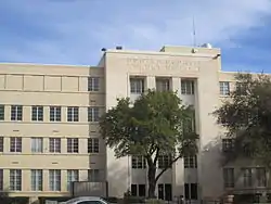 Howard County Court House in downtown Big Spring | |
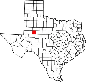 Location within the U.S. state of Texas | |
 Texas's location within the U.S. | |
| Coordinates: 32°19′N 101°26′W | |
| Country | |
| State | |
| Founded | 1882 |
| Named for | Volney E. Howard |
| Seat | Big Spring |
| Largest city | Big Spring |
| Area | |
| • Total | 904 sq mi (2,340 km2) |
| • Land | 901 sq mi (2,330 km2) |
| • Water | 3 sq mi (8 km2) 0.4%% |
| Population (2010) | |
| • Total | 35,012 |
| • Density | 39/sq mi (15/km2) |
| Time zone | UTC−6 (Central) |
| • Summer (DST) | UTC−5 (CDT) |
| Congressional district | 19th |
| Website | www |

Howard County is included in the Big Spring, Texas Micropolitan Statistical Area.
Geography
According to the U.S. Census Bureau, the county has a total area of 904 square miles (2,340 km2), of which 901 square miles (2,330 km2) are land and 3.4 square miles (8.8 km2) (0.4%) are covered by water.[5]
Howard County is located at the boundary between the Llano Estacado to the north and the Edwards Plateau to the south. Beals Creek, a tributary of the Colorado River, flows through the center of Big Spring and divides these two major physiographic regions.
Major highways
.svg.png.webp) Interstate 20
Interstate 20 Interstate 20 Business
 U.S. Highway 87
 State Highway 176
 State Highway 350
 Farm to Market Road 669
 Farm to Market Road 700
Adjacent counties
- Borden County (north)
- Mitchell County (east)
- Sterling County (southeast)
- Glasscock County (south)
- Martin County (west)
- Dawson County (northwest)
- Scurry County (northeast)
Demographics
| Historical population | |||
|---|---|---|---|
| Census | Pop. | %± | |
| 1880 | 50 | — | |
| 1890 | 1,210 | 2,320.0% | |
| 1900 | 2,528 | 108.9% | |
| 1910 | 8,881 | 251.3% | |
| 1920 | 6,962 | −21.6% | |
| 1930 | 22,888 | 228.8% | |
| 1940 | 20,990 | −8.3% | |
| 1950 | 26,722 | 27.3% | |
| 1960 | 40,139 | 50.2% | |
| 1970 | 37,796 | −5.8% | |
| 1980 | 33,142 | −12.3% | |
| 1990 | 32,343 | −2.4% | |
| 2000 | 33,627 | 4.0% | |
| 2010 | 35,012 | 4.1% | |
| 2019 (est.) | 36,664 | [6] | 4.7% |
| U.S. Decennial Census[7] 1850–2010[8] 2010–2014[1] | |||
Ar the 2000 census,[9] there were 33,627 people, 11,389 households and 7,949 families residing in the county. The population density was 37 per square mile (14/km2). There were 13,589 housing units at an average density of 15 per square mile (6/km2). The racial makeup of the county was 80.14% White, 4.13% Black or African American, 0.59% Native American, 0.59% Asian, 0.01% Pacific Islander, 12.43% from other races, and 2.10% from two or more races. 37.46% of the population were Hispanic or Latino of any race.
There were 11,389 households, of which 32.80% had children under the age of 18 living with them, 53.30% were married couples living together, 12.20% had a female householder with no husband present, and 30.20% were non-families. 26.80% of all households were made up of individuals, and 13.20% had someone living alone who was 65 years of age or older. The average household size was 2.53 and the average family size was 3.07.
24.20% of the population were under the age of 18, 9.00% from 18 to 24, 30.90% from 25 to 44, 21.30% from 45 to 64, and 14.60% who were 65 years of age or older. The median age was 36 years. For every 100 females there were 118.00 males. For every 100 females age 18 and over, there were 122.50 males.
The median household income was $30,805 and the median family income was $37,262. Males had a median income of $28,971 and females $21,390. The per capita income was $15,027. About 14.50% of families and 18.60% of the population were below the poverty line, including 24.70% of those under age 18 and 15.50% of those age 65 or over.
According to the United States Census Bureau Howard County, Texas has an estimated population of 36,459 as of July 1, 2018. That's a 4.1% increase from the 2010 census. 21.7% of the people are under 18 years old and 12.9% are older than 65 years old. OF the current population, 42.8% are female. In regards to race, 87.8% are white, 7.3% are black and 42.4% are Hispanic. The owner occupied housing rate is at 68.1%, with the median value of owner occupied housing being $85,700. High School graduates make up 82.1% of the population while only 12.9% have a Bachelor's degree or higher.[10]
Media
The county is served by a daily newspaper, local radio stations KBST (AM), KBST-FM, KBTS (FM), KBYG (AM), nearby stations KBXJ (FM), KPET (AM) and KWDC (FM), and the various Midland and Odessa radio and TV stations.
Politics
| Year | Republican | Democratic | Third parties |
|---|---|---|---|
| 2016 | 76.1% 6,637 | 20.3% 1,770 | 3.6% 316 |
| 2012 | 74.2% 6,453 | 24.3% 2,110 | 1.5% 132 |
| 2008 | 72.6% 7,029 | 26.3% 2,545 | 1.2% 115 |
| 2004 | 73.3% 7,480 | 26.1% 2,663 | 0.6% 58 |
| 2000 | 69.8% 6,668 | 28.7% 2,744 | 1.4% 136 |
| 1996 | 50.8% 5,007 | 37.9% 3,732 | 11.3% 1,118 |
| 1992 | 47.2% 5,129 | 34.4% 3,735 | 18.5% 2,009 |
| 1988 | 57.3% 6,024 | 42.3% 4,445 | 0.5% 48 |
| 1984 | 64.3% 7,519 | 35.2% 4,115 | 0.5% 57 |
| 1980 | 58.9% 6,658 | 39.4% 4,451 | 1.8% 203 |
| 1976 | 40.9% 4,899 | 58.3% 6,984 | 0.7% 89 |
| 1972 | 72.9% 7,343 | 26.9% 2,714 | 0.2% 23 |
| 1968 | 36.3% 3,812 | 37.1% 3,897 | 26.6% 2,792 |
| 1964 | 34.9% 3,272 | 64.9% 6,083 | 0.1% 12 |
| 1960 | 40.8% 3,403 | 58.1% 4,844 | 1.1% 88 |
| 1956 | 40.3% 3,051 | 59.5% 4,506 | 0.2% 14 |
| 1952 | 41.6% 3,412 | 58.3% 4,779 | 0.1% 11 |
| 1948 | 11.1% 561 | 82.7% 4,179 | 6.2% 312 |
| 1944 | 7.7% 334 | 82.8% 3,588 | 9.5% 412 |
| 1940 | 7.8% 367 | 92.1% 4,329 | 0.2% 7 |
| 1936 | 6.9% 230 | 92.9% 3,094 | 0.2% 8 |
| 1932 | 5.2% 149 | 94.4% 2,733 | 0.5% 13 |
| 1928 | 54.9% 812 | 44.9% 665 | 0.2% 3 |
| 1924 | 12.9% 186 | 76.0% 1,100 | 11.1% 161 |
| 1920 | 11.8% 107 | 77.5% 703 | 10.7% 97 |
| 1916 | 3.4% 30 | 85.2% 747 | 11.4% 100 |
| 1912 | 3.1% 22 | 75.6% 530 | 21.3% 149 |
See also
References
- "State & County QuickFacts". United States Census Bureau. Archived from the original on October 18, 2011. Retrieved December 17, 2013.
- "Find a County". National Association of Counties. Archived from the original on May 31, 2011. Retrieved June 7, 2011.
- "Texas: Individual County Chronologies". Texas Atlas of Historical County Boundaries. The Newberry Library. 2008. Retrieved May 24, 2015.
- Gannett, Henry (1905). The Origin of Certain Place Names in the United States. Govt. Print. Off. pp. 162.
- "2010 Census Gazetteer Files". United States Census Bureau. August 22, 2012. Retrieved April 30, 2015.
- "Population and Housing Unit Estimates". United States Census Bureau. May 24, 2020. Retrieved May 27, 2020.
- "U.S. Decennial Census". United States Census Bureau. Retrieved April 30, 2015.
- "Texas Almanac: Population History of Counties from 1850–2010" (PDF). Texas Almanac. Retrieved April 30, 2015.
- "U.S. Census website". United States Census Bureau. Retrieved May 14, 2011.
- https://www.census.gov/quickfacts/howardcountytexas
- Leip, David. "Dave Leip's Atlas of U.S. Presidential Elections". uselectionatlas.org. Retrieved July 25, 2018.
External links
| Wikimedia Commons has media related to Howard County, Texas. |
- Howard County government’s website
- Howard County from the Handbook of Texas Online
- Howard County Profile from the Texas Association of Counties
Places adjacent to Howard County, Texas | ||||||||||
|---|---|---|---|---|---|---|---|---|---|---|
| ||||||||||
Municipalities and communities of Howard County, Texas, United States | ||
|---|---|---|
| Cities | Howard County map | |
| Town | ||
| CDP | ||
| Other unincorporated communities | ||
| Ghost town | ||
| ||
