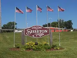
Sisseton, South Dakota
Sisseton is a city in Roberts County, South Dakota, United States. The population was 2,470 at the 2010 census. It is the county seat of Roberts County.[6] Sisseton is home to a number of attractions, including the Nicollet Tower, and is near the "Song to the Great Spirit" building on the Sisseton Wahpeton College campus. The city is named for the Sisseton (or Sissetowan) division of the Native American Sioux.[7] It also serves as an important part of the Lake Traverse Indian Reservation.[8]
Sisseton, South Dakota | |
|---|---|
 | |
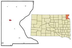 Location in Roberts County and the state of South Dakota | |
| Coordinates: 45°39′48″N 97°2′57″W | |
| Country | United States |
| State | South Dakota |
| County | Roberts |
| Incorporated | 1907[1] |
| Area | |
| • Total | 1.59 sq mi (4.12 km2) |
| • Land | 1.59 sq mi (4.12 km2) |
| • Water | 0.00 sq mi (0.00 km2) |
| Elevation | 1,224 ft (373 m) |
| Population | |
| • Total | 2,470 |
| • Estimate (2019)[4] | 2,398 |
| • Density | 1,507.23/sq mi (581.87/km2) |
| Time zone | UTC−6 (Central (CST)) |
| • Summer (DST) | UTC−5 (CDT) |
| ZIP code | 57262 |
| Area code(s) | Area code 793 |
| FIPS code | 46-59260 |
| GNIS feature ID | 1258093[5] |
| Website | sisseton.com |
Geography
Sisseton is located at 45°39′48″N 97°2′57″W (45.663259, −97.049040).[9] According to the United States Census Bureau, the city has a total area of 1.59 square miles (4.12 km2), all land.[10]
Sisseton has been assigned the ZIP code 57262 and the FIPS place code 59260.
| Climate data for Sisseton Municipal Airport, South Dakota (1981−2010 normals, extremes 1931−present[lower-alpha 1]) | |||||||||||||
|---|---|---|---|---|---|---|---|---|---|---|---|---|---|
| Month | Jan | Feb | Mar | Apr | May | Jun | Jul | Aug | Sep | Oct | Nov | Dec | Year |
| Record high °F (°C) | 65 (18) |
68 (20) |
82 (28) |
99 (37) |
113 (45) |
105 (41) |
113 (45) |
108 (42) |
102 (39) |
95 (35) |
79 (26) |
70 (21) |
113 (45) |
| Average high °F (°C) | 23.0 (−5.0) |
27.5 (−2.5) |
39.3 (4.1) |
56.3 (13.5) |
69.4 (20.8) |
77.3 (25.2) |
82.9 (28.3) |
80.8 (27.1) |
72.2 (22.3) |
57.2 (14.0) |
40.2 (4.6) |
26.1 (−3.3) |
54.5 (12.5) |
| Average low °F (°C) | 3.3 (−15.9) |
8.7 (−12.9) |
20.8 (−6.2) |
32.6 (0.3) |
45.1 (7.3) |
54.8 (12.7) |
59.5 (15.3) |
57.4 (14.1) |
47.3 (8.5) |
35.5 (1.9) |
21.5 (−5.8) |
7.9 (−13.4) |
33.0 (0.6) |
| Record low °F (°C) | −37 (−38) |
−33 (−36) |
−29 (−34) |
−3 (−19) |
19 (−7) |
32 (0) |
40 (4) |
35 (2) |
22 (−6) |
4 (−16) |
−18 (−28) |
−30 (−34) |
−37 (−38) |
| Average precipitation inches (mm) | 0.43 (11) |
0.43 (11) |
1.12 (28) |
2.28 (58) |
2.72 (69) |
3.74 (95) |
3.58 (91) |
2.44 (62) |
2.54 (65) |
2.08 (53) |
0.58 (15) |
0.39 (9.9) |
22.33 (567) |
| Average snowfall inches (cm) | 8.4 (21) |
8.4 (21) |
8.3 (21) |
3.8 (9.7) |
0 (0) |
0 (0) |
0 (0) |
0 (0) |
0 (0) |
0.7 (1.8) |
7.3 (19) |
7.6 (19) |
44.5 (113) |
| Average precipitation days (≥ 0.01 in) | 4.4 | 4.7 | 5.7 | 6.8 | 10.4 | 10.3 | 8.8 | 8.1 | 8.6 | 7.0 | 4.7 | 4.4 | 83.9 |
| Average snowy days (≥ 0.1 in) | 4.4 | 4.2 | 3.3 | 1.2 | 0 | 0 | 0 | 0 | 0 | 0.4 | 3.1 | 4.1 | 20.7 |
| Source: NOAA (snow, precipitation day normals at COOP 45°39′56″N 97°02′22″W)[12][13][14] | |||||||||||||
- Notes
- Records maintained at the airport since August 27, 1998, and at the Sisseton COOP before that.[11]
Demographics
| Historical population | |||
|---|---|---|---|
| Census | Pop. | %± | |
| 1900 | 928 | — | |
| 1910 | 1,397 | 50.5% | |
| 1920 | 1,431 | 2.4% | |
| 1930 | 1,569 | 9.6% | |
| 1940 | 2,513 | 60.2% | |
| 1950 | 2,871 | 14.2% | |
| 1960 | 3,218 | 12.1% | |
| 1970 | 3,094 | −3.9% | |
| 1980 | 2,789 | −9.9% | |
| 1990 | 2,181 | −21.8% | |
| 2000 | 2,572 | 17.9% | |
| 2010 | 2,470 | −4.0% | |
| 2019 (est.) | 2,398 | [4] | −2.9% |
| U.S. Decennial Census[15] 2018 Estimate | |||
2010 census
As of the census[3] of 2010, there were 2,470 people, 958 households, and 576 families living in the city. The population density was 1,553.5 inhabitants per square mile (599.8/km2). There were 1,057 housing units at an average density of 664.8 per square mile (256.7/km2). The racial makeup of the city was 47.0% White, 0.1% African American, 47.8% Native American, 0.4% Asian, 0.2% from other races, and 4.5% from two or more races. Hispanic or Latino of any race were 1.6% of the population.
There were 958 households, of which 36.3% had children under the age of 18 living with them, 34.2% were married couples living together, 17.1% had a female householder with no husband present, 8.8% had a male householder with no wife present, and 39.9% were non-families. 34.9% of all households were made up of individuals, and 16.3% had someone living alone who was 65 years of age or older. The average household size was 2.48 and the average family size was 3.22.
The median age in the city was 34.6 years. 29.7% of residents were under the age of 18; 9% were between the ages of 18 and 24; 22.1% were from 25 to 44; 21.9% were from 45 to 64; and 17.4% were 65 years of age or older. The gender makeup of the city was 48.1% male and 51.9% female.
2000 census
As of the census of 2000, there were 2,572 people, 1,003 households, and 631 families living in the city. The population density was 1,636.7 people per square mile (632.5/km2). There were 1,093 housing units at an average density of 695.5 per square mile (268.8/km2). The racial makeup of the city was 56.07% White, 0.12% African American, 40.86% Native American, 0.27% Asian, 0.04% from other races, and 2.64% from two or more races. Hispanic or Latino of any race were 1.09% of the population.
There were 1,003 households, out of which 31.9% had children under the age of 18 living with them, 38.9% were married couples living together, 16.9% had a female householder with no husband present, and 37.0% were non-families. 34.6% of all households were made up of individuals, and 16.2% had someone living alone who was 65 years of age or older. The average household size was 2.46 and the average family size was 3.12.
In the city, the population was spread out, with 29.3% under the age of 18, 8.2% from 18 to 24, 23.3% from 25 to 44, 20.8% from 45 to 64, and 18.4% who were 65 years of age or older. The median age was 36 years. For every 100 females, there were 88.8 males. For every 100 females age 18 and over, there were 86.2 males.
As of 2000 the median income for a household in the city was $26,698, and the median income for a family was $33,977. Males had a median income of $27,393 versus $20,586 for females. The per capita income for the city was $14,019. About 14.9% of families and 18.4% of the population were below the poverty line, including 23.6% of those under age 18 and 16.4% of those age 65 or over.
Education
Sisseton Wahpeton College, a small college that is part of Sisseton Wahpeton Oyate, is near Sisseton in Agency Village. The college offers undergraduate and vocational degrees. About 80% of the college's 250 students are Dakota people.
The Sisseton School District has four schools: Sisseton High School, Sisseton Middle School, New Effington Elementary and Westside Elementary.[16]
Media
FM radio
| FM radio stations | ||||||
|---|---|---|---|---|---|---|
| Frequency | Call sign | Name | Format | Owner | Target city/market | City of license |
| 89.9 FM | KXSW | Country/Rock | Corporation for Native Broadcasting | Sisseton | Sisseton | |
| 99.5 FM | KJKQ | Jack FM | Adult Hits | Armada Media | Sisseton | Sisseton |
| 102.9 FM | KBWS-FM | Pheasant Country 103 | Country | Armada Media | Sisseton | Sisseton |
Notable people
- Greg Long, musician
- Lowell Lundstrom, nationally known American evangelist and musician
- "Mean" Gene Okerlund, professional wrestling interviewer
- Gabriel Renville, last chief of the Sisseton-Wahpeton Sioux tribe
- Joe Robbie, original owner of the Miami Dolphins
- Floyd Westerman, actor
References
- "SD Towns" (PDF). South Dakota State Historical Society. Retrieved 2010-02-15.
- "2019 U.S. Gazetteer Files". United States Census Bureau. Retrieved July 30, 2020.
- "U.S. Census website". United States Census Bureau. Retrieved 2012-06-21.
- "Population and Housing Unit Estimates". United States Census Bureau. May 24, 2020. Retrieved May 27, 2020.
- "US Board on Geographic Names". United States Geological Survey. 2007-10-25. Retrieved 2008-01-31.
- "Find a County". National Association of Counties. Retrieved 2011-06-07.
- Federal Writers' Project (1940). South Dakota place-names, v.1-3. University of South Dakota. p. 61.
- http://www.nativepartnership.org/site/PageServer?pagename=airc_res_sd_sisseton
- "US Gazetteer files: 2010, 2000, and 1990". United States Census Bureau. 2011-02-12. Retrieved 2011-04-23.
- "US Gazetteer files 2010". United States Census Bureau. Archived from the original on 2012-01-25. Retrieved 2012-06-21.
- http://threadex.rcc-acis.org/
- "NOWData – NOAA Online Weather Data". National Oceanic and Atmospheric Administration. Retrieved 2020-09-16.
- "Station Name: SD SISSETON". National Oceanic and Atmospheric Administration. Retrieved 2020-09-16.
- "Station Name: SD SISSETON MUNICIPAL AP". National Oceanic and Atmospheric Administration. Retrieved 2020-09-16.
- United States Census Bureau. "Census of Population and Housing". Retrieved July 20, 2014.
- "Search for Public School Districts – District Detail for Sisseton School District 54-2". National Center for Education Statistics. Institute of Education Sciences. Retrieved Feb 7, 2015.
External links
Municipalities and communities of Roberts County, South Dakota, United States | ||
|---|---|---|
| Cities | 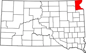 | |
| Towns | ||
| CDPs | ||
| Townships | ||
| Unincorporated community | ||
| Indian reservation | ||
| Footnotes | ‡This populated place also has portions in an adjacent county or counties | |
| ||

| Authority control |
|---|