Hutchinson County, South Dakota
Hutchinson County is a county in the U.S. state of South Dakota. As of the 2010 United States Census, the population was 7,343.[1] Its county seat is Olivet.[2] The county was created in 1862 and organized in 1871; it was named for John Hutchinson, first territorial secretary.[3]
Hutchinson County | |
|---|---|
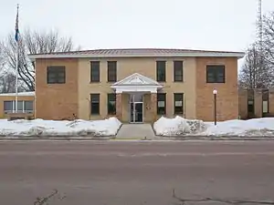 Hutchinson County Courthouse in Olivet | |
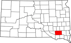 Location within the U.S. state of South Dakota | |
 South Dakota's location within the U.S. | |
| Coordinates: 43°20′N 97°45′W | |
| Country | |
| State | |
| Founded | 1862 (created) 1871 (organized) |
| Named for | John Hutchinson |
| Seat | Olivet |
| Largest city | Parkston |
| Area | |
| • Total | 814 sq mi (2,110 km2) |
| • Land | 813 sq mi (2,110 km2) |
| • Water | 1.5 sq mi (4 km2) 0.2% |
| Population (2010) | |
| • Total | 7,343 |
| • Estimate (2018) | 7,380 |
| • Density | 9.0/sq mi (3.5/km2) |
| Time zone | UTC−6 (Central) |
| • Summer (DST) | UTC−5 (CDT) |
| Congressional district | At-large |
History
Hutchinson County was created by act of the territorial legislature on May 8, 1862. Its boundaries included portions of present-day Davison and Hanson Counties, and part of what is presently Hutchinson County was within the boundaries of Jayne County. Maxwell City was established as the county seat, and it remained there until October 1873 when it was moved to Olivet following an election. On 13 January 1871, the territorial legislature established the present county boundaries and completed its governing organization. In two actions in January 1873, the legislature divided Hutchinson County into two counties - the northern half was named Armstrong County, with Milltown as the seat. However, in 1879, Armstrong County was dissolved and its area re-annexed into Hutchinson County.[4][5][6]
Geography
The James River flows south-southeasterly through the central part of Hutchinson County. The county's terrain consists of rolling hills, with the area largely devoted to agriculture.[7] The terrain slopes to the river valley from both sides, with the county's highest point at its southwest corner: 1,880' (573m) ASL.[8]
Hutchinson County has a total area of 814 square miles (2,110 km2), of which 813 square miles (2,110 km2) is land and 1.5 square miles (3.9 km2) (0.2%) is water.[9]
Major highways
 U.S. Highway 18
 U.S. Highway 81
 South Dakota Highway 25
 South Dakota Highway 37
 South Dakota Highway 44
Adjacent counties
- Hanson County - north
- McCook County - northeast
- Turner County - east
- Yankton County - southeast
- Bon Homme County - south
- Charles Mix County - southwest
- Douglas County - west
- Davison County - northwest
Protected areas[7]
- Mogck Slough State Public Shooting Area
- Weigher Slough State Public Shooting Area
Lakes[7]
- Lake Dimock
- Lake Menno
- Silver Lake
- Tripp Lake
Demographics
| Historical population | |||
|---|---|---|---|
| Census | Pop. | %± | |
| 1870 | 37 | — | |
| 1880 | 5,573 | 14,962.2% | |
| 1890 | 10,469 | 87.9% | |
| 1900 | 11,897 | 13.6% | |
| 1910 | 12,319 | 3.5% | |
| 1920 | 13,475 | 9.4% | |
| 1930 | 13,904 | 3.2% | |
| 1940 | 12,668 | −8.9% | |
| 1950 | 11,423 | −9.8% | |
| 1960 | 11,085 | −3.0% | |
| 1970 | 10,379 | −6.4% | |
| 1980 | 9,350 | −9.9% | |
| 1990 | 8,262 | −11.6% | |
| 2000 | 8,075 | −2.3% | |
| 2010 | 7,343 | −9.1% | |
| 2019 (est.) | 7,291 | [10] | −0.7% |
| US Decennial Census[11] 1790-1960[12] 1900-1990[13] 1990-2000[14] 2010-2018[1] | |||
2000 census
As of the 2000 United States Census,[15] there were 8,075 people, 3,190 households, and 2,191 families in the county. The population density was 10 people per square mile (4/km2). There were 3,517 housing units at an average density of 4 per square mile (2/km2). The racial makeup of the county was 98.82% White, 0.09% Black or African American, 0.57% Native American, 0.10% Asian, 0.06% from other races, and 0.36% from two or more races. 0.52% of the population were Hispanic or Latino of any race.
63% of the population of Hutchinson County reports German ancestry and 8.3% speak German at home.
There were 3,190 households, out of which 28.00% had children under the age of 18 living with them, 61.50% were married couples living together, 4.40% had a female householder with no husband present, and 31.30% were non-families. 29.60% of all households were made up of individuals, and 18.50% had someone living alone who was 65 years of age or older. The average household size was 2.43 and the average family size was 3.03.
The county population contained 24.90% under the age of 18, 5.60% from 18 to 24, 22.10% from 25 to 44, 21.20% from 45 to 64, and 26.20% who were 65 years of age or older. The median age was 43 years. For every 100 females there were 94.90 males. For every 100 females age 18 and over, there were 90.70 males.
The median income for a household in the county was $30,026, and the median income for a family was $37,715. Males had a median income of $25,654 versus $18,141 for females. The per capita income for the county was $15,922. About 9.60% of families and 13.00% of the population were below the poverty line, including 18.30% of those under age 18 and 11.30% of those age 65 or over.
2010 census
As of the 2010 United States Census, there were 7,343 people, 2,930 households, and 1,871 families in the county.[16] The population density was 9.0 inhabitants per square mile (3.5/km2). There were 3,351 housing units at an average density of 4.1 per square mile (1.6/km2).[17] The racial makeup of the county was 97.4% white, 0.7% American Indian, 0.4% black or African American, 0.2% Asian, 0.5% from other races, and 0.9% from two or more races. Those of Hispanic or Latino origin made up 1.6% of the population.[16] In terms of ancestry, 67.7% were German, 8.7% were Russian, 7.4% were Norwegian, 6.9% were Irish, and 3.6% were American.[18]
Of the 2,930 households, 24.6% had children under the age of 18 living with them, 55.6% were married couples living together, 5.0% had a female householder with no husband present, 36.1% were non-families, and 33.4% of all households were made up of individuals. The average household size was 2.22 and the average family size was 2.82. The median age was 46.8 years.[16]
The median income for a household in the county was $39,310 and the median income for a family was $52,390. Males had a median income of $35,180 versus $25,417 for females. The per capita income for the county was $21,944. About 6.4% of families and 10.4% of the population were below the poverty line, including 11.5% of those under age 18 and 14.5% of those age 65 or over.[19]
Mennonites and Hutterites
Hutchinson County is the most heavily Mennonite-populated county of South Dakota. German-speaking Mennonites from Russia settled in the county beginning in 1874 until the early 1880s.[20] South Dakota has the nation's largest population of Hutterites,[21] a communal Anabaptist group that emigrated also from Russia during the same period as the Mennonites, with whom they share the Anabaptist faith. Hutterites live in communities each of about 150 people. Wolf Creek Colony is in Hutchinson County, where the Wolf meets the James River. This colony is west of Freeman and north of Olivet and Menno.[22]
Communities
Unincorporated communities[7]
- Clayton
- Lake Tripp
- Wolf Creek
Townships
- Capital
- Clayton
- Cross Plains
- Fair
- Foster
- German
- Grandview
- Kassel
- Kaylor
- Kulm
- Liberty
- Mittown
- Molan
- Oak Hollow
- Pleasant
- Sharon
- Silver Lake
- Starr
- Susquehanna
- Sweet
- Valley
- Wittenberg
- Wolf Creek
Politics
Like most of South Dakota, Hutchinson County is overwhelmingly Republican. Only one Democratic presidential candidate – Franklin D. Roosevelt in his 1932 landslide – has ever carried the county. Surprisingly, in the 1928 and 1972 Republican landslides Hutchinson County actually voted more Democratic than the nation at-large due to German Lutheran anti-Prohibition voting for Al Smith in the first case and a strong “favorite son” vote for George McGovern in the latter. Apart from these two hugely anomalous cases, only four Democrats have ever topped forty percent of the county's vote, and only four statewide Republican nominees failed to win a majority.
| Year | Republican | Democratic | Third parties |
|---|---|---|---|
| 2020 | 78.2% 2,944 | 20.2% 762 | 1.6% 61 |
| 2016 | 74.8% 2,517 | 20.6% 692 | 4.6% 156 |
| 2012 | 71.6% 2,451 | 27.0% 923 | 1.5% 51 |
| 2008 | 63.3% 2,285 | 34.4% 1,242 | 2.3% 81 |
| 2004 | 69.9% 2,899 | 28.4% 1,177 | 1.7% 71 |
| 2000 | 68.9% 2,497 | 29.0% 1,052 | 2.1% 76 |
| 1996 | 55.7% 2,177 | 32.9% 1,285 | 11.5% 449 |
| 1992 | 48.2% 2,002 | 29.1% 1,211 | 22.7% 943 |
| 1988 | 62.6% 2,700 | 36.9% 1,594 | 0.5% 22 |
| 1984 | 72.9% 3,372 | 26.8% 1,237 | 0.3% 15 |
| 1980 | 73.2% 3,789 | 22.1% 1,145 | 4.8% 246 |
| 1976 | 57.5% 2,822 | 42.0% 2,062 | 0.5% 22 |
| 1972 | 57.8% 3,092 | 42.0% 2,248 | 0.2% 8 |
| 1968 | 69.1% 3,544 | 27.5% 1,412 | 3.4% 175 |
| 1964 | 56.9% 2,884 | 43.2% 2,189 | |
| 1960 | 71.7% 3,948 | 28.3% 1,557 | |
| 1956 | 73.2% 3,870 | 26.8% 1,420 | |
| 1952 | 83.2% 4,322 | 16.8% 875 | |
| 1948 | 70.0% 2,906 | 29.1% 1,209 | 0.9% 36 |
| 1944 | 84.5% 3,799 | 15.5% 699 | |
| 1940 | 82.1% 5,051 | 17.9% 1,103 | |
| 1936 | 48.3% 2,804 | 43.1% 2,500 | 8.6% 497 |
| 1932 | 29.0% 1,504 | 69.9% 3,630 | 1.1% 58 |
| 1928 | 52.6% 2,145 | 46.6% 1,898 | 0.8% 34 |
| 1924 | 24.7% 893 | 5.0% 180 | 70.4% 2,550 |
| 1920 | 51.2% 1,873 | 6.6% 243 | 42.2% 1,546 |
| 1916 | 73.2% 1,636 | 23.2% 519 | 3.6% 80 |
| 1912 | 30.3% 647 | 69.8% 1,492 | |
| 1908 | 69.0% 1,507 | 28.4% 619 | 2.6% 57 |
| 1904 | 80.3% 1,752 | 16.7% 365 | 2.9% 64 |
| 1900 | 73.5% 1,528 | 25.7% 534 | 0.9% 18 |
| 1896 | 75.0% 1,413 | 24.3% 458 | 0.7% 14 |
| 1892 | 64.4% 1,034 | 15.8% 254 | 19.8% 317 |
References
- "State & County QuickFacts". United States Census Bureau. Archived from the original on June 7, 2011. Retrieved November 25, 2013.
- "Find a County". National Association of Counties. Archived from the original on May 31, 2011. Retrieved June 7, 2011.
- Gannett, Henry (1905). The Origin of Certain Place Names in the United States. Govt. Print. Off. p. 164.
- The Territorial Legislature ordered the re-uniting of the two counties into one, apparently against the desires of Armstrong County officials. The legislature ordered the county officers of Armstrong County to deliver their records, money and papers to Olivet. However, the Armstrong people refused and continued to serve as county officers until a court decision in 1881 compelled them to surrender the records.
- "Dakota Territory, South Dakota, and North Dakota: Individual County Chronologies". Dakota Territory Atlas of Historical County Boundaries. The Newberry Library. 2006. Retrieved March 29, 2015.
- History, First Circuit Court, SD Unified Justice System (accessed February 4, 2019)
- Hutchinson County SD Google Maps (accessed February 4, 2019)
- ""Find an Altitude" Google Maps (accessed 4 February 2019)". Archived from the original on 21 May 2019. Retrieved 4 February 2019.
- "2010 Census Gazetteer Files". US Census Bureau. August 22, 2012. Retrieved March 26, 2015.
- "Annual Estimates of the Resident Population for Counties: April 1, 2010 to July 1, 2019". Retrieved April 10, 2020.
- "US Decennial Census". US Census Bureau. Retrieved March 26, 2015.
- "Historical Census Browser". University of Virginia Library. Retrieved March 26, 2015.
- Forstall, Richard L., ed. (March 27, 1995). "Population of Counties by Decennial Census: 1900 to 1990". US Census Bureau. Retrieved March 26, 2015.
- "Census 2000 PHC-T-4. Ranking Tables for Counties: 1990 and 2000" (PDF). US Census Bureau. April 2, 2001. Retrieved March 26, 2015.
- "U.S. Census website". US Census Bureau. Retrieved 14 May 2011.
- "Profile of General Population and Housing Characteristics: 2010 Demographic Profile Data". US Census Bureau. Archived from the original on 13 February 2020. Retrieved 12 March 2016.
- "Population, Housing Units, Area, and Density: 2010 - County". US Census Bureau. Archived from the original on 13 February 2020. Retrieved 12 March 2016.
- "Selected Social Characteristics in the US – 2006-2010 American Community Survey 5-Year Estimates". US Census Bureau. Archived from the original on 13 February 2020. Retrieved 12 March 2016.
- "Selected Economic Characteristics – 2006-2010 American Community Survey 5-Year Estimates". US Census Bureau. Archived from the original on 13 February 2020. Retrieved 12 March 2016.
- Unruh, J. D. (1956). "Hutchinson County (South Dakota, USA)". Global Anabaptist Mennonite Encyclopedia Online. Retrieved July 30, 2015.
- "Color them plain but successful". The Federal Reserve Bank of Minneapolis. Retrieved 14 December 2008.
- Johnson, Dirk (November 25, 1987). "Wolf Creek Journal; Idealists With a Knack For Being Prosperous". The New York Times. Retrieved June 20, 2015.
- Leip, David. "Atlas of US Presidential Elections". uselectionatlas.org. Retrieved 15 April 2018.
Places adjacent to Hutchinson County, South Dakota | ||||||||||
|---|---|---|---|---|---|---|---|---|---|---|
| ||||||||||
Municipalities and communities of Hutchinson County, South Dakota, United States | ||
|---|---|---|
| Cities | | |
| Towns | ||
| CDPs | ||
| ||

| Authority control |
|---|